San Torcuato geodata
San Torcuato (La Rioja) is a seat of a third-order administrative division; located in Spain in Europe/Madrid (GMT+2) time zone. With population of 122 people, there are 5674 cities with bigger population in this country. Compared to other cities in Spain, 86.8% of cities are located further ↓South; 56.1% of cities are located further ←West and 54.6% of cities have higher elevation than San Torcuato. Note1


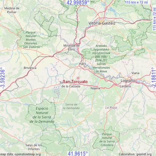
San Torcuato GPS coordinates[2]
42° 28' 55.884" North, 2° 53' 21.228" West
| Map corner | latitude | longitude |
|---|---|---|
| Upper-left | 42.99859°, | -3.59236° |
| Center: | 42.48219°, | -2.88923° |
| Lower-right: | 41.9615°, | -2.18611° |
| Map W x H: | 115.3×115.3 km | = 71.6×71.6mi |
| max Lat: | 43.74134° ⇑13.2% North |
| San Torcuato: | 42.48219° |
| min Lat: | ⇓86.8% South 27.64134° |
| min Long | San Torcuato | max Long |
| -18.00367° | -2.88923° | 4.2899° |
| W 56.1%⇐ | ⇒43.9% E |
Elevation
Elevation of San Torcuato is 601 m = 1972 ft, and this is 3 m = 10 ft above average elevation for this country.
| Max E: |
1682 m = 5518 ft | 54.6% |
| San Torcuato | 601 m 1972 ft | |
| Avg. | 598 m = 1962 ft | |
Min E: |
0 m = 0 ft | 45.4% |
See also: Spain elevation on elevation.city.
Geographical zone
San Torcuato is located in North temperate zone (between Tropic of Cancer and the Arctic Circle). Distance of this Northern Tropic circle is 2117.7 km =1315.9 mi to South.| Distance of | km | miles | from San Torcuato |
|---|---|---|---|
| North Pole | 5283.5 | 3283 | to North |
| Arctic Circle | 2677.6 | 1663.8 | to North |
| Tropic Cancer | 2117.7 | 1315.9 | to South |
| Equator | 4723.6 | 2935.1 | to South |


Nearby cities:
15 places around San Torcuato: (largest is in red/bold)
• Bañares
2.3 km =1.4 mi,  228°
228°
• Baños de Rioja
5.8 km =3.6 mi,  305°
305°
• Casalarreina
7.6 km =4.7 mi,  347°
347°
• Castañares de Rioja
4.8 km =3 mi, 314°
• Cidamón
1.7 km =1.1 mi,  31°
31°
• Cirueña
7.8 km =4.8 mi,  184°
184°
• Cuzcurrita de Río Tirón
9 km =5.6 mi,  317°
317°
• Gimileo
9.3 km =5.8 mi,  36°
36°
• Hervías
3.8 km =2.4 mi, 177°
• Ollauri
8.1 km =5 mi, 33°
• Rodezno
6 km =3.7 mi, 36°
• Santo Domingo de la Calzada
7.1 km =4.4 mi, 228°
• Tirgo
8.6 km =5.3 mi,  325°
325°
• Villalobar de Rioja
6.2 km =3.9 mi,  279°
279°
• Zarratón
3.9 km =2.4 mi,  10°
10°
Sources, notices
• [Note1] Compared only with cities in Spain existing in our database
• [Src1] Map data: © OpenStreetMap contributors (CC-BY-SA)
• [Src2] Other city data from geonames.org with taken over terms of usage.
• [Src3] Geographical zone / Annual Mean Temperature by Robert A. Rohde @ Wikipedia
