Cirueña geodata
Cirueña (La Rioja) is a seat of a third-order administrative division; located in Spain in Europe/Madrid (GMT+2) time zone. With population of 115 people, there are 5757 cities with bigger population in this country. Compared to other cities in Spain, 85.2% of cities are located further ↓South; 55.9% of cities are located further ←West and 60% of cities have lower elevation than Cirueña. Note1


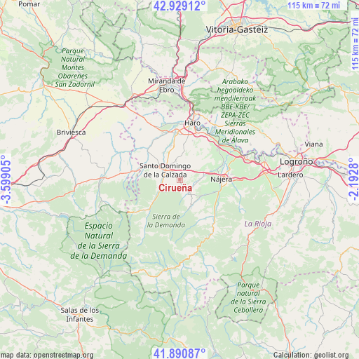
Cirueña GPS coordinates[2]
42° 24' 43.704" North, 2° 53' 45.348" West
| Map corner | latitude | longitude |
|---|---|---|
| Upper-left | 42.92912°, | -3.59905° |
| Center: | 42.41214°, | -2.89593° |
| Lower-right: | 41.89087°, | -2.1928° |
| Map W x H: | 115.4×115.4 km | = 71.7×71.7mi |
| max Lat: | 43.74134° ⇑14.8% North |
| Cirueña: | 42.41214° |
| min Lat: | ⇓85.2% South 27.64134° |
| min Long | Cirueña | max Long |
| -18.00367° | -2.89593° | 4.2899° |
| W 55.9%⇐ | ⇒44.1% E |
Elevation
Elevation of Cirueña is 745 m = 2444 ft, and this is 147 m = 482 ft above average elevation for this country.
| Max E: |
1682 m = 5518 ft | 40% |
| Cirueña | 745 m 2444 ft | |
| Avg. | 598 m = 1962 ft | |
Min E: |
0 m = 0 ft | 60% |
See also: Spain elevation on elevation.city.
Geographical zone
Cirueña is located in North temperate zone (between Tropic of Cancer and the Arctic Circle). Distance of this Northern Tropic circle is 2109.9 km =1311 mi to South.| Distance of | km | miles | from Cirueña |
|---|---|---|---|
| North Pole | 5291.3 | 3287.9 | to North |
| Arctic Circle | 2685.4 | 1668.6 | to North |
| Tropic Cancer | 2109.9 | 1311 | to South |
| Equator | 4715.8 | 2930.3 | to South |


Nearby cities:
15 places around Cirueña: (largest is in red/bold)
• Alesanco
6.5 km =4 mi,  88°
88°
• Azofra
7.9 km =4.9 mi,  80°
80°
• Badarán
8.5 km =5.3 mi,  125°
125°
• Bañares
6.4 km =4 mi,  349°
349°
• Canillas de Río Tuerto
4.7 km =2.9 mi,  107°
107°
• Cañas
4.6 km =2.9 mi,  118°
118°
• Cordovín
7.3 km =4.5 mi, 113°
• Hervías
4 km =2.5 mi,  10°
10°
• Manzanares de Rioja
1.8 km =1.1 mi,  179°
179°
• San Torcuato
7.8 km =4.8 mi,  4°
4°
• Santo Domingo de la Calzada
5.7 km =3.5 mi,  303°
303°
• Santurdejo
6.2 km =3.9 mi,  230°
230°
• Torrecilla sobre Alesanco
5.1 km =3.2 mi, 94°
• Villar de Torre
5.2 km =3.2 mi,  150°
150°
• Villarejo
4.3 km =2.7 mi,  170°
170°
Sources, notices
• [Note1] Compared only with cities in Spain existing in our database
• [Src1] Map data: © OpenStreetMap contributors (CC-BY-SA)
• [Src2] Other city data from geonames.org with taken over terms of usage.
• [Src3] Geographical zone / Annual Mean Temperature by Robert A. Rohde @ Wikipedia
