Rodezno geodata
Rodezno (La Rioja) is a seat of a third-order administrative division; located in Spain in Europe/Madrid (GMT+2) time zone. With population of 335 people, there are 4371 cities with bigger population in this country. Compared to other cities in Spain, 87.9% of cities are located further ↓South; 56.8% of cities are located further ←West and 58.5% of cities have higher elevation than Rodezno. Note1


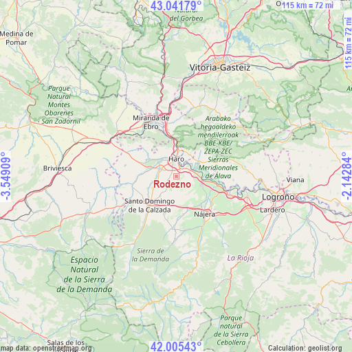
Rodezno GPS coordinates[2]
42° 31' 32.736" North, 2° 50' 45.492" West
| Map corner | latitude | longitude |
|---|---|---|
| Upper-left | 43.04179°, | -3.54909° |
| Center: | 42.52576°, | -2.84597° |
| Lower-right: | 42.00543°, | -2.14284° |
| Map W x H: | 115.2×115.2 km | = 71.6×71.6mi |
| max Lat: | 43.74134° ⇑12.1% North |
| Rodezno: | 42.52576° |
| min Lat: | ⇓87.9% South 27.64134° |
| min Long | Rodezno | max Long |
| -18.00367° | -2.84597° | 4.2899° |
| W 56.8%⇐ | ⇒43.2% E |
Elevation
Elevation of Rodezno is 548 m = 1798 ft, and this is 50 m = 164 ft below average elevation for this country.
| Max E: |
1682 m = 5518 ft | 58.5% |
| Avg. | 598 m = 1962 ft | |
| Rodezno | 548 m = 1798 ft | |
Min E: |
0 m = 0 ft | 41.5% |
See also: Spain elevation on elevation.city.
Geographical zone
Rodezno is located in North temperate zone (between Tropic of Cancer and the Arctic Circle). Distance of this Northern Tropic circle is 2122.5 km =1318.9 mi to South.| Distance of | km | miles | from Rodezno |
|---|---|---|---|
| North Pole | 5278.6 | 3280 | to North |
| Arctic Circle | 2672.8 | 1660.8 | to North |
| Tropic Cancer | 2122.5 | 1318.9 | to South |
| Equator | 4728.4 | 2938.1 | to South |


Nearby cities:
15 places around Rodezno: (largest is in red/bold)
• Anguciana
7 km =4.3 mi,  319°
319°
• Bastida / Labastida
8.2 km =5.1 mi,  30°
30°
• Bañares
8.3 km =5.2 mi,  219°
219°
• Baños de Rioja
8.4 km =5.2 mi,  259°
259°
• Briones
5.3 km =3.3 mi,  67°
67°
• Casalarreina
5.8 km =3.6 mi,  296°
296°
• Castañares de Rioja
7.2 km =4.5 mi, 258°
• Cidamón
4.3 km =2.7 mi, 217°
• Cihuri
7.7 km =4.8 mi, 304°
• Gimileo
3.3 km =2.1 mi,  35°
35°
• Haro
5.6 km =3.5 mi,  358°
358°
• Ollauri
2.1 km =1.3 mi, 26°
• San Torcuato
6 km =3.7 mi, 216°
• San Vicente de la Sonsierra
8.1 km =5 mi,  59°
59°
• Zarratón
3 km =1.9 mi,  250°
250°
Sources, notices
• [Note1] Compared only with cities in Spain existing in our database
• [Src1] Map data: © OpenStreetMap contributors (CC-BY-SA)
• [Src2] Other city data from geonames.org with taken over terms of usage.
• [Src3] Geographical zone / Annual Mean Temperature by Robert A. Rohde @ Wikipedia
