Hervías geodata
Hervías (La Rioja) is a seat of a third-order administrative division; located in Spain in Europe/Madrid (GMT+2) time zone. With population of 131 people, there are 5570 cities with bigger population in this country. Compared to other cities in Spain, 86.1% of cities are located further ↓South; 56.1% of cities are located further ←West and 51.2% of cities have higher elevation than Hervías. Note1


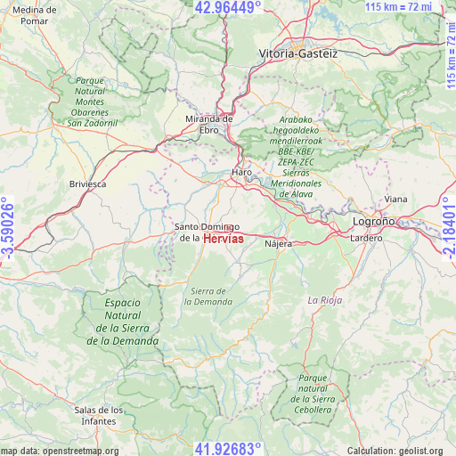
Hervías GPS coordinates[2]
42° 26' 52.116" North, 2° 53' 13.704" West
| Map corner | latitude | longitude |
|---|---|---|
| Upper-left | 42.96449°, | -3.59026° |
| Center: | 42.44781°, | -2.88714° |
| Lower-right: | 41.92683°, | -2.18401° |
| Map W x H: | 115.4×115.4 km | = 71.7×71.7mi |
| max Lat: | 43.74134° ⇑13.9% North |
| Hervías: | 42.44781° |
| min Lat: | ⇓86.1% South 27.64134° |
| min Long | Hervías | max Long |
| -18.00367° | -2.88714° | 4.2899° |
| W 56.1%⇐ | ⇒43.9% E |
Elevation
Elevation of Hervías is 646 m = 2119 ft, and this is 48 m = 157 ft above average elevation for this country.
| Max E: |
1682 m = 5518 ft | 51.2% |
| Hervías | 646 m 2119 ft | |
| Avg. | 598 m = 1962 ft | |
Min E: |
0 m = 0 ft | 48.8% |
See also: Spain elevation on elevation.city.
Geographical zone
Hervías is located in North temperate zone (between Tropic of Cancer and the Arctic Circle). Distance of this Northern Tropic circle is 2113.8 km =1313.5 mi to South.| Distance of | km | miles | from Hervías |
|---|---|---|---|
| North Pole | 5287.3 | 3285.4 | to North |
| Arctic Circle | 2681.4 | 1666.1 | to North |
| Tropic Cancer | 2113.8 | 1313.5 | to South |
| Equator | 4719.8 | 2932.7 | to South |


Nearby cities:
15 places around Hervías: (largest is in red/bold)
• Alesanco
6.9 km =4.3 mi,  122°
122°
• Azofra
7.6 km =4.7 mi,  110°
110°
• Bañares
3 km =1.9 mi,  320°
320°
• Canillas de Río Tuerto
6.6 km =4.1 mi,  144°
144°
• Castañares de Rioja
8.1 km =5 mi,  333°
333°
• Cañas
7 km =4.3 mi,  151°
151°
• Cidamón
5.3 km =3.3 mi,  7°
7°
• Cirueña
4 km =2.5 mi,  190°
190°
• Manzanares de Rioja
5.8 km =3.6 mi, 187°
• San Torcuato
3.8 km =2.4 mi,  357°
357°
• Santo Domingo de la Calzada
5.5 km =3.4 mi,  261°
261°
• Torrecilla sobre Alesanco
6.2 km =3.9 mi, 135°
• Villalobar de Rioja
7.9 km =4.9 mi,  307°
307°
• Villarejo
8.2 km =5.1 mi,  179°
179°
• Zarratón
7.7 km =4.8 mi,  3°
3°
Sources, notices
• [Note1] Compared only with cities in Spain existing in our database
• [Src1] Map data: © OpenStreetMap contributors (CC-BY-SA)
• [Src2] Other city data from geonames.org with taken over terms of usage.
• [Src3] Geographical zone / Annual Mean Temperature by Robert A. Rohde @ Wikipedia
