Sant Pere de Riudebitlles geodata
Sant Pere de Riudebitlles (Catalonia) is a populated place; located in Spain in Europe/Madrid (GMT+2) time zone. With population of 2,113 people, there are 2093 cities with bigger population in this country. Compared to other cities in Spain, 59.5% of cities are located further ↓South; 92.3% of cities are located further ←West and 77.4% of cities have higher elevation than Sant Pere de Riudebitlles. Note1
Current local time in Sant Pere de Riudebitlles:
10:46 PM, ThursdayDifference from your time zone: hours


Sant Pere de Riudebitlles GPS coordinates[2]
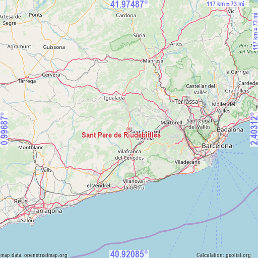
41° 27' 0" North, 1° 42' 0" East
| Map corner | latitude | longitude |
|---|---|---|
| Upper-left | 41.97487°, | 0.99687° |
| Center: | 41.45°, | 1.7° |
| Lower-right: | 40.92085°, | 2.40312° |
| Map W x H: | 117.2×117.2 km | = 72.8×72.8mi |
| max Lat: | 43.74134° ⇑40.5% North |
| Sant Pere de Riudebitlles: | 41.45° |
| min Lat: | ⇓59.5% South 27.64134° |
| min Long | Sant Pere de Ri | max Long |
| -18.00367° | 1.7° | 4.2899° |
| W 92.3%⇐ | ⇒7.7% E |
Elevation
Elevation of Sant Pere de Riudebitlles is 264 m = 866 ft, and this is 334 m = 1096 ft below average elevation for this country.
| Max E: |
1682 m = 5518 ft | 77.4% |
| Avg. | 598 m = 1962 ft | |
| Sant Pere de Riudebitlles | 264 m = 866 ft | |
Min E: |
0 m = 0 ft | 22.6% |
See also: Spain elevation on elevation.city.
Geographical zone
Sant Pere de Riudebitlles is located in North temperate zone (between Tropic of Cancer and the Arctic Circle). Distance of this Northern Tropic circle is 2002.9 km =1244.5 mi to South.| Distance of | km | miles | from Sant Pere de Riudebitlles |
|---|---|---|---|
| North Pole | 5398.3 | 3354.3 | to North |
| Arctic Circle | 2792.4 | 1735.1 | to North |
| Tropic Cancer | 2002.9 | 1244.5 | to South |
| Equator | 4608.8 | 2863.8 | to South |


Nearby cities:
15 places around Sant Pere de Riudebitlles: (largest is in red/bold)
• Capellades
9 km =5.6 mi,  352°
352°
• Carme
11.3 km =7 mi,  324°
324°
• La Granada
8.1 km =5 mi,  168°
168°
• La Pobla de Claramunt
11.7 km =7.3 mi, 350°
• Masquefa
11 km =6.8 mi,  57°
57°
• Mediona
7.9 km =4.9 mi,  293°
293°
• Piera
9.1 km =5.7 mi,  27°
27°
• Sant Joan de Mediona
8 km =5 mi, 293°
• Sant Llorenç d'Hortons
11.3 km =7 mi,  80°
80°
• Sant Martí Sarroca
10.3 km =6.4 mi,  226°
226°
• Sant Pere Molanta
11.8 km =7.3 mi,  163°
163°
• Sant Sadurní d'Anoia
7.6 km =4.7 mi,  110°
110°
• Vilafranca del Penedès
11.5 km =7.1 mi,  181°
181°
• Vilobí del Penedès
8.5 km =5.3 mi,  209°
209°
• el Pla del Penedès
4 km =2.5 mi, 159°
Sources, notices
• [Note1] Compared only with cities in Spain existing in our database
• [Src1] Map data: © OpenStreetMap contributors (CC-BY-SA)
• [Src2] Other city data from geonames.org with taken over terms of usage.
• [Src3] Geographical zone / Annual Mean Temperature by Robert A. Rohde @ Wikipedia
