Piera geodata
Piera (Catalonia) is a populated place; located in Spain in Europe/Madrid (GMT+2) time zone. With population of 14,324 people, there are 642 cities with bigger population in this country. Compared to other cities in Spain, 61.3% of cities are located further ↓South; 92.4% of cities are located further ←West and 74.1% of cities have higher elevation than Piera. Note1
Administrative division(s):
- Level 1: Catalonia
- Level 2: Província de Barcelona
- Level 3: Cabrera d'Anoia


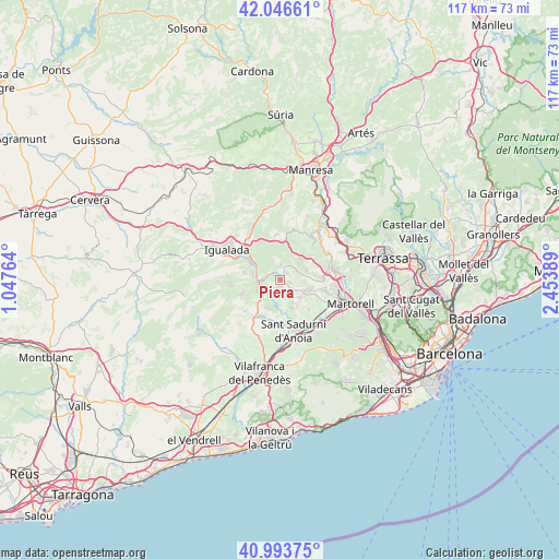
Piera GPS coordinates[2]
41° 31' 20.352" North, 1° 45' 2.736" East
| Map corner | latitude | longitude |
|---|---|---|
| Upper-left | 42.04661°, | 1.04764° |
| Center: | 41.52232°, | 1.75076° |
| Lower-right: | 40.99375°, | 2.45389° |
| Map W x H: | 117.1×117.1 km | = 72.8×72.8mi |
| max Lat: | 43.74134° ⇑38.7% North |
| Piera: | 41.52232° |
| min Lat: | ⇓61.3% South 27.64134° |
| min Long | Piera | max Long |
| -18.00367° | 1.75076° | 4.2899° |
| W 92.4%⇐ | ⇒7.6% E |
Elevation
Elevation of Piera is 313 m = 1027 ft, and this is 285 m = 935 ft below average elevation for this country.
| Max E: |
1682 m = 5518 ft | 74.1% |
| Avg. | 598 m = 1962 ft | |
| Piera | 313 m = 1027 ft | |
Min E: |
0 m = 0 ft | 25.9% |
See also: Spain elevation on elevation.city.
Geographical zone
Piera is located in North temperate zone (between Tropic of Cancer and the Arctic Circle). Distance of this Northern Tropic circle is 2010.9 km =1249.5 mi to South.| Distance of | km | miles | from Piera |
|---|---|---|---|
| North Pole | 5390.2 | 3349.3 | to North |
| Arctic Circle | 2784.3 | 1730.1 | to North |
| Tropic Cancer | 2010.9 | 1249.5 | to South |
| Equator | 4616.8 | 2868.7 | to South |


Nearby cities:
15 places around Piera: (largest is in red/bold)
• Abrera
12.5 km =7.8 mi,  92°
92°
• Capellades
5.4 km =3.4 mi,  279°
279°
• Carme
10.9 km =6.8 mi, 275°
• Castellolí
9.4 km =5.8 mi,  333°
333°
• Collbató
8.3 km =5.2 mi,  50°
50°
• Esparreguera
10.1 km =6.3 mi,  80°
80°
• La Pobla de Claramunt
7.1 km =4.4 mi,  300°
300°
• Masquefa
5.5 km =3.4 mi,  112°
112°
• Olesa de Montserrat
12.2 km =7.6 mi, 78°
• Sant Llorenç d'Hortons
9.3 km =5.8 mi,  131°
131°
• Sant Pere de Riudebitlles
9.1 km =5.7 mi,  207°
207°
• Sant Sadurní d'Anoia
11.1 km =6.9 mi,  165°
165°
• Vilanova del Camí
10.9 km =6.8 mi, 300°
• el Pla del Penedès
12.1 km =7.5 mi,  193°
193°
• Òdena
12 km =7.5 mi,  315°
315°
Sources, notices
• [Note1] Compared only with cities in Spain existing in our database
• [Src1] Map data: © OpenStreetMap contributors (CC-BY-SA)
• [Src2] Other city data from geonames.org with taken over terms of usage.
• [Src3] Geographical zone / Annual Mean Temperature by Robert A. Rohde @ Wikipedia
