Capellades geodata
Capellades (Catalonia) is a seat of a third-order administrative division; located in Spain in Europe/Madrid (GMT+2) time zone. With population of 5,187 people, there are 1268 cities with bigger population in this country. Compared to other cities in Spain, 61.5% of cities are located further ↓South; 92.3% of cities are located further ←West and 73.5% of cities have higher elevation than Capellades. Note1


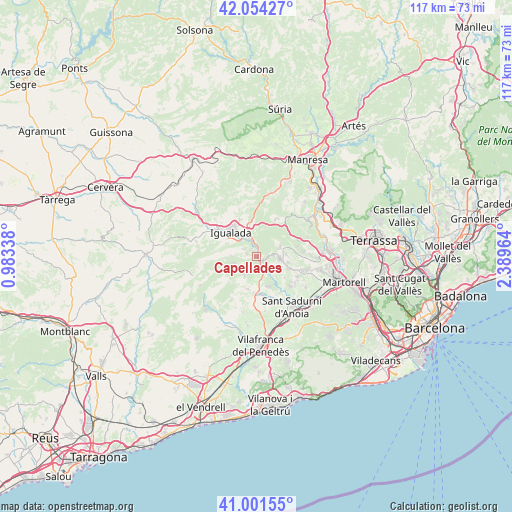
Capellades GPS coordinates[2]
41° 31' 48.18" North, 1° 41' 11.436" East
| Map corner | latitude | longitude |
|---|---|---|
| Upper-left | 42.05427°, | 0.98338° |
| Center: | 41.53005°, | 1.68651° |
| Lower-right: | 41.00155°, | 2.38964° |
| Map W x H: | 117.1×117.1 km | = 72.8×72.8mi |
| max Lat: | 43.74134° ⇑38.5% North |
| Capellades: | 41.53005° |
| min Lat: | ⇓61.5% South 27.64134° |
| min Long | Capellades | max Long |
| -18.00367° | 1.68651° | 4.2899° |
| W 92.3%⇐ | ⇒7.7% E |
Elevation
Elevation of Capellades is 324 m = 1063 ft, and this is 274 m = 899 ft below average elevation for this country.
| Max E: |
1682 m = 5518 ft | 73.5% |
| Avg. | 598 m = 1962 ft | |
| Capellades | 324 m = 1063 ft | |
Min E: |
0 m = 0 ft | 26.5% |
See also: Spain elevation on elevation.city.
Geographical zone
Capellades is located in North temperate zone (between Tropic of Cancer and the Arctic Circle). Distance of this Northern Tropic circle is 2011.8 km =1250.1 mi to South.| Distance of | km | miles | from Capellades |
|---|---|---|---|
| North Pole | 5389.4 | 3348.8 | to North |
| Arctic Circle | 2783.5 | 1729.6 | to North |
| Tropic Cancer | 2011.8 | 1250.1 | to South |
| Equator | 4617.7 | 2869.3 | to South |


Nearby cities:
15 places around Capellades: (largest is in red/bold)
• Carme
5.5 km =3.4 mi,  272°
272°
• Castellolí
7.7 km =4.8 mi,  8°
8°
• Collbató
12.5 km =7.8 mi,  69°
69°
• Igualada
8.1 km =5 mi,  314°
314°
• La Pobla de Claramunt
2.8 km =1.7 mi,  343°
343°
• Masquefa
10.8 km =6.7 mi,  105°
105°
• Mediona
8.5 km =5.3 mi,  226°
226°
• Orpí
9.3 km =5.8 mi,  262°
262°
• Piera
5.4 km =3.4 mi,  99°
99°
• Sant Joan de Mediona
8.5 km =5.3 mi, 227°
• Sant Llorenç d'Hortons
14.1 km =8.8 mi,  119°
119°
• Sant Pere de Riudebitlles
9 km =5.6 mi,  172°
172°
• Vilanova del Camí
6.2 km =3.9 mi,  318°
318°
• el Pla del Penedès
12.9 km =8 mi, 168°
• Òdena
8.3 km =5.2 mi, 338°
Sources, notices
• [Note1] Compared only with cities in Spain existing in our database
• [Src1] Map data: © OpenStreetMap contributors (CC-BY-SA)
• [Src2] Other city data from geonames.org with taken over terms of usage.
• [Src3] Geographical zone / Annual Mean Temperature by Robert A. Rohde @ Wikipedia
