Masquefa geodata
Masquefa (Catalonia) is a seat of a third-order administrative division; located in Spain in Europe/Madrid (GMT+2) time zone. With population of 7,150 people, there are 1020 cities with bigger population in this country. Compared to other cities in Spain, 60.9% of cities are located further ↓South; 92.6% of cities are located further ←West and 77.9% of cities have higher elevation than Masquefa. Note1


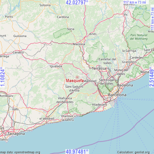
Masquefa GPS coordinates[2]
41° 30' 12.708" North, 1° 48' 40.896" East
| Map corner | latitude | longitude |
|---|---|---|
| Upper-left | 42.02797°, | 1.10824° |
| Center: | 41.50353°, | 1.81136° |
| Lower-right: | 40.97481°, | 2.51449° |
| Map W x H: | 117.1×117.1 km | = 72.8×72.8mi |
| max Lat: | 43.74134° ⇑39.1% North |
| Masquefa: | 41.50353° |
| min Lat: | ⇓60.9% South 27.64134° |
| min Long | Masquefa | max Long |
| -18.00367° | 1.81136° | 4.2899° |
| W 92.6%⇐ | ⇒7.4% E |
Elevation
Elevation of Masquefa is 257 m = 843 ft, and this is 341 m = 1119 ft below average elevation for this country.
| Max E: |
1682 m = 5518 ft | 77.9% |
| Avg. | 598 m = 1962 ft | |
| Masquefa | 257 m = 843 ft | |
Min E: |
0 m = 0 ft | 22.1% |
See also: Spain elevation on elevation.city.
Geographical zone
Masquefa is located in North temperate zone (between Tropic of Cancer and the Arctic Circle). Distance of this Northern Tropic circle is 2008.8 km =1248.2 mi to South.| Distance of | km | miles | from Masquefa |
|---|---|---|---|
| North Pole | 5392.3 | 3350.6 | to North |
| Arctic Circle | 2786.4 | 1731.4 | to North |
| Tropic Cancer | 2008.8 | 1248.2 | to South |
| Equator | 4614.8 | 2867.5 | to South |


Nearby cities:
15 places around Masquefa: (largest is in red/bold)
• Abrera
7.6 km =4.7 mi,  78°
78°
• Capellades
10.8 km =6.7 mi,  285°
285°
• Castellví de Rosanes
9.5 km =5.9 mi,  128°
128°
• Collbató
7.5 km =4.7 mi,  10°
10°
• Esparreguera
6.2 km =3.9 mi,  51°
51°
• Gelida
9.1 km =5.7 mi,  149°
149°
• Martorell
10.5 km =6.5 mi,  108°
108°
• Olesa de Montserrat
8.2 km =5.1 mi,  57°
57°
• Piera
5.5 km =3.4 mi, 292°
• Sant Llorenç d'Hortons
4.5 km =2.8 mi,  155°
155°
• Sant Pere de Riudebitlles
11 km =6.8 mi,  237°
237°
• Sant Sadurní d'Anoia
8.9 km =5.5 mi,  194°
194°
• Subirats
11.7 km =7.3 mi,  170°
170°
• Ullastrell
12.3 km =7.6 mi, 78°
• el Pla del Penedès
12.5 km =7.8 mi,  219°
219°
Sources, notices
• [Note1] Compared only with cities in Spain existing in our database
• [Src1] Map data: © OpenStreetMap contributors (CC-BY-SA)
• [Src2] Other city data from geonames.org with taken over terms of usage.
• [Src3] Geographical zone / Annual Mean Temperature by Robert A. Rohde @ Wikipedia
