San Llorente geodata
San Llorente (Castille and León) is a seat of a third-order administrative division; located in Spain in Europe/Madrid (GMT+2) time zone. With population of 170 people, there are 5264 cities with bigger population in this country. Compared to other cities in Spain, 65.8% of cities are located further ↓South; 60.8% of cities are located further →East and 79% of cities have lower elevation than San Llorente. Note1
Administrative division(s):
- Level 1: Castille and León
- Level 2: Provincia de Valladolid
- Level 3: San Llorente


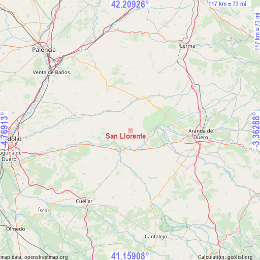
San Llorente GPS coordinates[2]
41° 41' 10.716" North, 4° 3' 57.6" West
| Map corner | latitude | longitude |
|---|---|---|
| Upper-left | 42.20926°, | -4.76913° |
| Center: | 41.68631°, | -4.066° |
| Lower-right: | 41.15908°, | -3.36288° |
| Map W x H: | 116.8×116.8 km | = 72.6×72.6mi |
| max Lat: | 43.74134° ⇑34.2% North |
| San Llorente: | 41.68631° |
| min Lat: | ⇓65.8% South 27.64134° |
| min Long | San Llorente | max Long |
| -18.00367° | -4.066° | 4.2899° |
| W 39.2%⇐ | ⇒60.8% E |
Elevation
Elevation of San Llorente is 889 m = 2917 ft, and this is 291 m = 955 ft above average elevation for this country.
| Max E: |
1682 m = 5518 ft | 21% |
| San Llorente | 889 m 2917 ft | |
| Avg. | 598 m = 1962 ft | |
Min E: |
0 m = 0 ft | 79% |
See also: Spain elevation on elevation.city.
Geographical zone
San Llorente is located in North temperate zone (between Tropic of Cancer and the Arctic Circle). Distance of this Northern Tropic circle is 2029.2 km =1260.9 mi to South.| Distance of | km | miles | from San Llorente |
|---|---|---|---|
| North Pole | 5372 | 3338 | to North |
| Arctic Circle | 2766.1 | 1718.8 | to North |
| Tropic Cancer | 2029.2 | 1260.9 | to South |
| Equator | 4635.1 | 2880.1 | to South |


Nearby cities:
15 places around San Llorente: (largest is in red/bold)
• Bocos de Duero
7 km =4.3 mi,  183°
183°
• Canillas de Esgueva
9 km =5.6 mi,  327°
327°
• Corrales de Duero
2.2 km =1.4 mi,  136°
136°
• Curiel de Duero
5.6 km =3.5 mi,  211°
211°
• Encinas de Esgueva
8.4 km =5.2 mi,  338°
338°
• Mambrilla de Castrejón
7.1 km =4.4 mi,  108°
108°
• Pedrosa de Duero
7.1 km =4.4 mi,  65°
65°
• Pesquera de Duero
9 km =5.6 mi,  236°
236°
• Peñafiel
10.2 km =6.3 mi,  203°
203°
• Piñel de Abajo
6.8 km =4.2 mi,  258°
258°
• Piñel de Arriba
5.4 km =3.4 mi,  285°
285°
• Roturas
4.9 km =3 mi,  245°
245°
• San Martín de Rubiales
7.9 km =4.9 mi,  128°
128°
• Valdearcos de la Vega
5.1 km =3.2 mi,  163°
163°
• Villaescusa de Roa
6.1 km =3.8 mi,  41°
41°
Sources, notices
• [Note1] Compared only with cities in Spain existing in our database
• [Src1] Map data: © OpenStreetMap contributors (CC-BY-SA)
• [Src2] Other city data from geonames.org with taken over terms of usage.
• [Src3] Geographical zone / Annual Mean Temperature by Robert A. Rohde @ Wikipedia
