Piñel de Abajo geodata
Piñel de Abajo (Castille and León) is a seat of a third-order administrative division; located in Spain in Europe/Madrid (GMT+2) time zone. With population of 189 people, there are 5115 cities with bigger population in this country. Compared to other cities in Spain, 65.4% of cities are located further ↓South; 61.9% of cities are located further →East and 66.8% of cities have lower elevation than Piñel de Abajo. Note1
Administrative division(s):
- Level 1: Castille and León
- Level 2: Provincia de Valladolid
- Level 3: Piñel de Abajo


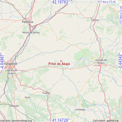
Piñel de Abajo GPS coordinates[2]
41° 40' 28.524" North, 4° 8' 47.58" West
| Map corner | latitude | longitude |
|---|---|---|
| Upper-left | 42.19763°, | -4.84967° |
| Center: | 41.67459°, | -4.14655° |
| Lower-right: | 41.14726°, | -3.44342° |
| Map W x H: | 116.8×116.8 km | = 72.6×72.6mi |
| max Lat: | 43.74134° ⇑34.6% North |
| Piñel de Abajo: | 41.67459° |
| min Lat: | ⇓65.4% South 27.64134° |
| min Long | Piñel de Abajo | max Long |
| -18.00367° | -4.14655° | 4.2899° |
| W 38.1%⇐ | ⇒61.9% E |
Elevation
Elevation of Piñel de Abajo is 790 m = 2592 ft, and this is 192 m = 630 ft above average elevation for this country.
| Max E: |
1682 m = 5518 ft | 33.2% |
| Piñel de Abajo | 790 m 2592 ft | |
| Avg. | 598 m = 1962 ft | |
Min E: |
0 m = 0 ft | 66.8% |
See also: Spain elevation on elevation.city.
Geographical zone
Piñel de Abajo is located in North temperate zone (between Tropic of Cancer and the Arctic Circle). Distance of this Northern Tropic circle is 2027.9 km =1260.1 mi to South.| Distance of | km | miles | from Piñel de Abajo |
|---|---|---|---|
| North Pole | 5373.3 | 3338.8 | to North |
| Arctic Circle | 2767.4 | 1719.6 | to North |
| Tropic Cancer | 2027.9 | 1260.1 | to South |
| Equator | 4633.8 | 2879.3 | to South |


Nearby cities:
15 places around Piñel de Abajo: (largest is in red/bold)
• Bocos de Duero
8.5 km =5.3 mi,  132°
132°
• Canillas de Esgueva
9.1 km =5.7 mi,  11°
11°
• Castroverde de Cerrato
11 km =6.8 mi,  325°
325°
• Corrales de Duero
8.2 km =5.1 mi,  91°
91°
• Curiel de Duero
5.1 km =3.2 mi, 132°
• Encinas de Esgueva
9.8 km =6.1 mi,  21°
21°
• Fombellida
10.7 km =6.6 mi,  343°
343°
• Manzanillo
10.4 km =6.5 mi,  199°
199°
• Pesquera de Duero
3.7 km =2.3 mi,  191°
191°
• Peñafiel
8.5 km =5.3 mi,  161°
161°
• Piñel de Arriba
3.1 km =1.9 mi,  29°
29°
• Quintanilla de Arriba
8.5 km =5.3 mi,  224°
224°
• Roturas
2.4 km =1.5 mi,  107°
107°
• San Llorente
6.8 km =4.2 mi,  78°
78°
• Valdearcos de la Vega
8.9 km =5.5 mi, 113°
Sources, notices
• [Note1] Compared only with cities in Spain existing in our database
• [Src1] Map data: © OpenStreetMap contributors (CC-BY-SA)
• [Src2] Other city data from geonames.org with taken over terms of usage.
• [Src3] Geographical zone / Annual Mean Temperature by Robert A. Rohde @ Wikipedia
