Peñafiel geodata
Peñafiel (Castille and León) is a seat of a third-order administrative division; located in Spain in Europe/Madrid (GMT+2) time zone. With population of 5,455 people, there are 1223 cities with bigger population in this country. Compared to other cities in Spain, 63.5% of cities are located further ↓South; 61.4% of cities are located further →East and 61.9% of cities have lower elevation than Peñafiel. Note1
Administrative division(s):
- Level 1: Castille and León
- Level 2: Provincia de Valladolid
- Level 3: Peñafiel


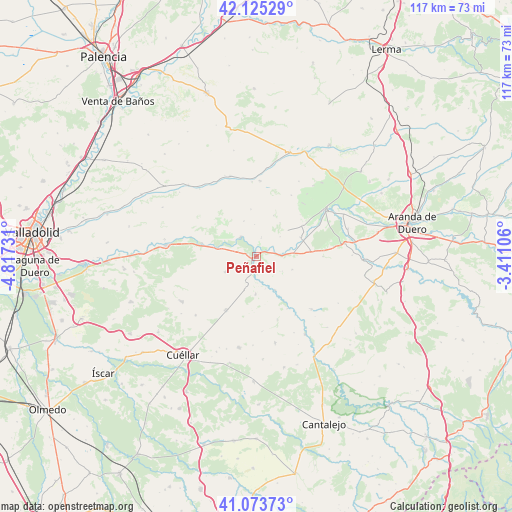
Peñafiel GPS coordinates[2]
41° 36' 5.94" North, 4° 6' 51.048" West
| Map corner | latitude | longitude |
|---|---|---|
| Upper-left | 42.12529°, | -4.81731° |
| Center: | 41.60165°, | -4.11418° |
| Lower-right: | 41.07373°, | -3.41106° |
| Map W x H: | 116.9×116.9 km | = 72.6×72.6mi |
| max Lat: | 43.74134° ⇑36.5% North |
| Peñafiel: | 41.60165° |
| min Lat: | ⇓63.5% South 27.64134° |
| min Long | Peñafiel | max Long |
| -18.00367° | -4.11418° | 4.2899° |
| W 38.6%⇐ | ⇒61.4% E |
Elevation
Elevation of Peñafiel is 756 m = 2480 ft, and this is 158 m = 518 ft above average elevation for this country.
| Max E: |
1682 m = 5518 ft | 38.1% |
| Peñafiel | 756 m 2480 ft | |
| Avg. | 598 m = 1962 ft | |
Min E: |
0 m = 0 ft | 61.9% |
See also: Spain elevation on elevation.city.
Geographical zone
Peñafiel is located in North temperate zone (between Tropic of Cancer and the Arctic Circle). Distance of this Northern Tropic circle is 2019.8 km =1255 mi to South.| Distance of | km | miles | from Peñafiel |
|---|---|---|---|
| North Pole | 5381.4 | 3343.8 | to North |
| Arctic Circle | 2775.5 | 1724.6 | to North |
| Tropic Cancer | 2019.8 | 1255 | to South |
| Equator | 4625.7 | 2874.3 | to South |


Nearby cities:
15 places around Peñafiel: (largest is in red/bold)
• Bocos de Duero
4.4 km =2.7 mi,  56°
56°
• Canalejas de Peñafiel
8.5 km =5.3 mi,  180°
180°
• Castrillo de Duero
8.7 km =5.4 mi,  109°
109°
• Curiel de Duero
4.8 km =3 mi,  13°
13°
• Fompedraza
7.8 km =4.8 mi,  199°
199°
• Langayo
7.9 km =4.9 mi,  243°
243°
• Manzanillo
6.4 km =4 mi,  254°
254°
• Olmos de Peñafiel
6.8 km =4.2 mi,  119°
119°
• Pesquera de Duero
5.6 km =3.5 mi,  322°
322°
• Piñel de Abajo
8.5 km =5.3 mi,  341°
341°
• Quintanilla de Arriba
8.8 km =5.5 mi,  283°
283°
• Roturas
7.4 km =4.6 mi,  356°
356°
• Rábano
8.8 km =5.5 mi,  150°
150°
• Torre de Peñafiel
7.6 km =4.7 mi,  163°
163°
• Valdearcos de la Vega
7.1 km =4.4 mi,  50°
50°
Sources, notices
• [Note1] Compared only with cities in Spain existing in our database
• [Src1] Map data: © OpenStreetMap contributors (CC-BY-SA)
• [Src2] Other city data from geonames.org with taken over terms of usage.
• [Src3] Geographical zone / Annual Mean Temperature by Robert A. Rohde @ Wikipedia
