Sant Jaume dels Domenys geodata
Sant Jaume dels Domenys (Catalonia) is a seat of a third-order administrative division; located in Spain in Europe/Madrid (GMT+2) time zone. In our database, there are 6762 cities with bigger population. Compared to other cities in Spain, 55.3% of cities are located further ↓South; 92% of cities are located further ←West and 81.4% of cities have higher elevation than Sant Jaume dels Domenys. Note1
Administrative division(s):
- Level 1: Catalonia
- Level 2: Província de Tarragona
- Level 3: Sant Jaume dels Domenys
Current local time in Sant Jaume dels Domenys:
10:45 PM, ThursdayDifference from your time zone: hours


Sant Jaume dels Domenys GPS coordinates[2]
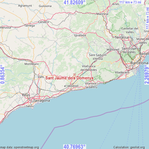
41° 18' 0" North, 1° 34' 0.012" East
| Map corner | latitude | longitude |
|---|---|---|
| Upper-left | 41.82609°, | 0.86354° |
| Center: | 41.3°, | 1.56667° |
| Lower-right: | 40.76963°, | 2.26979° |
| Map W x H: | 117.5×117.5 km | = 73×73mi |
| max Lat: | 43.74134° ⇑44.7% North |
| Sant Jaume dels Domenys: | 41.3° |
| min Lat: | ⇓55.3% South 27.64134° |
| min Long | Sant Jaume dels | max Long |
| -18.00367° | 1.56667° | 4.2899° |
| W 92%⇐ | ⇒8% E |
Elevation
Elevation of Sant Jaume dels Domenys is 197 m = 646 ft, and this is 401 m = 1316 ft below average elevation for this country.
| Max E: |
1682 m = 5518 ft | 81.4% |
| Avg. | 598 m = 1962 ft | |
| Sant Jaume dels Domenys | 197 m = 646 ft | |
Min E: |
0 m = 0 ft | 18.6% |
See also: Spain elevation on elevation.city.
Geographical zone
Sant Jaume dels Domenys is located in North temperate zone (between Tropic of Cancer and the Arctic Circle). Distance of this Northern Tropic circle is 1986.2 km =1234.2 mi to South.| Distance of | km | miles | from Sant Jaume dels Domenys |
|---|---|---|---|
| North Pole | 5414.9 | 3364.7 | to North |
| Arctic Circle | 2809 | 1745.4 | to North |
| Tropic Cancer | 1986.2 | 1234.2 | to South |
| Equator | 4592.1 | 2853.4 | to South |


Nearby cities:
15 places around Sant Jaume dels Domenys: (largest is in red/bold)
• Albinyana
8.9 km =5.5 mi,  231°
231°
• Bonastre
13.8 km =8.6 mi, 230°
• Calafell
11.1 km =6.9 mi,  179°
179°
• Castellet
7 km =4.3 mi,  126°
126°
• Coma-ruga
13.8 km =8.6 mi,  194°
194°
• Cubelles
13.6 km =8.5 mi,  139°
139°
• Cunit
12.7 km =7.9 mi,  152°
152°
• El Vendrell
9.7 km =6 mi,  196°
196°
• La Granada
15.4 km =9.6 mi,  55°
55°
• Sant Martí Sarroca
10.2 km =6.3 mi,  21°
21°
• Sant Pere Molanta
15.4 km =9.6 mi,  69°
69°
• Santa Oliva
5.3 km =3.3 mi, 194°
• Vilafranca del Penedès
12 km =7.5 mi, 64°
• Vilobí del Penedès
11.6 km =7.2 mi,  36°
36°
• la Bisbal del Penedès
7.2 km =4.5 mi,  255°
255°
Sources, notices
• [Note1] Compared only with cities in Spain existing in our database
• [Src1] Map data: © OpenStreetMap contributors (CC-BY-SA)
• [Src2] Other city data from geonames.org with taken over terms of usage.
• [Src3] Geographical zone / Annual Mean Temperature by Robert A. Rohde @ Wikipedia
