Castellet geodata
Castellet (Catalonia) is a populated place; located in Spain in Europe/Madrid (GMT+2) time zone. With population of 7,713 people, there are 962 cities with bigger population in this country. Compared to other cities in Spain, 54.6% of cities are located further ↓South; 92.1% of cities are located further ←West and 86.6% of cities have higher elevation than Castellet. Note1
Administrative division(s):
- Level 1: Catalonia
- Level 2: Província de Barcelona
- Level 3: Castellet i la Gornal


Castellet GPS coordinates[2]
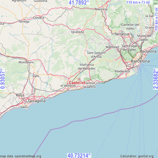
41° 15' 46.116" North, 1° 38' 1.284" East
| Map corner | latitude | longitude |
|---|---|---|
| Upper-left | 41.7892°, | 0.93057° |
| Center: | 41.26281°, | 1.63369° |
| Lower-right: | 40.73214°, | 2.33682° |
| Map W x H: | 117.5×117.5 km | = 73×73mi |
| max Lat: | 43.74134° ⇑45.4% North |
| Castellet: | 41.26281° |
| min Lat: | ⇓54.6% South 27.64134° |
| min Long | Castellet | max Long |
| -18.00367° | 1.63369° | 4.2899° |
| W 92.1%⇐ | ⇒7.9% E |
Elevation
Elevation of Castellet is 114 m = 374 ft, and this is 484 m = 1588 ft below average elevation for this country.
| Max E: |
1682 m = 5518 ft | 86.6% |
| Avg. | 598 m = 1962 ft | |
| Castellet | 114 m = 374 ft | |
Min E: |
0 m = 0 ft | 13.4% |
See also: Spain elevation on elevation.city.
Geographical zone
Castellet is located in North temperate zone (between Tropic of Cancer and the Arctic Circle). Distance of this Northern Tropic circle is 1982.1 km =1231.6 mi to South.| Distance of | km | miles | from Castellet |
|---|---|---|---|
| North Pole | 5419.1 | 3367.3 | to North |
| Arctic Circle | 2813.2 | 1748 | to North |
| Tropic Cancer | 1982.1 | 1231.6 | to South |
| Equator | 4588 | 2850.9 | to South |


Nearby cities:
15 places around Castellet: (largest is in red/bold)
• Albinyana
12.6 km =7.8 mi,  263°
263°
• Calafell
8.9 km =5.5 mi,  218°
218°
• Coma-ruga
12.9 km =8 mi, 224°
• Cubelles
6.9 km =4.3 mi,  151°
151°
• Cunit
7.2 km =4.5 mi,  178°
178°
• El Vendrell
9.8 km =6.1 mi,  238°
238°
• Sant Jaume dels Domenys
7 km =4.3 mi,  306°
306°
• Sant Martí Sarroca
13.8 km =8.6 mi,  352°
352°
• Sant Pere Molanta
13 km =8.1 mi,  43°
43°
• Sant Pere de Ribes
11.7 km =7.3 mi,  91°
91°
• Santa Oliva
7 km =4.3 mi, 261°
• Vilafranca del Penedès
10.7 km =6.6 mi,  29°
29°
• Vilanova i la Geltrú
8.8 km =5.5 mi,  119°
119°
• Vilobí del Penedès
13.5 km =8.4 mi,  5°
5°
• la Bisbal del Penedès
12.8 km =8 mi,  280°
280°
Sources, notices
• [Note1] Compared only with cities in Spain existing in our database
• [Src1] Map data: © OpenStreetMap contributors (CC-BY-SA)
• [Src2] Other city data from geonames.org with taken over terms of usage.
• [Src3] Geographical zone / Annual Mean Temperature by Robert A. Rohde @ Wikipedia
