Cubelles geodata
Cubelles (Catalonia) is a seat of a third-order administrative division; located in Spain in Europe/Madrid (GMT+2) time zone. With population of 13,711 people, there are 676 cities with bigger population in this country. Compared to other cities in Spain, 53.3% of cities are located further ↓South; 92.2% of cities are located further ←West and 97.6% of cities have higher elevation than Cubelles. Note1


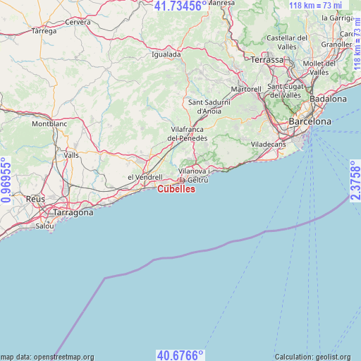
Cubelles GPS coordinates[2]
41° 12' 27.792" North, 1° 40' 21.612" East
| Map corner | latitude | longitude |
|---|---|---|
| Upper-left | 41.73456°, | 0.96955° |
| Center: | 41.20772°, | 1.67267° |
| Lower-right: | 40.6766°, | 2.3758° |
| Map W x H: | 117.6×117.6 km | = 73.1×73.1mi |
| max Lat: | 43.74134° ⇑46.7% North |
| Cubelles: | 41.20772° |
| min Lat: | ⇓53.3% South 27.64134° |
| min Long | Cubelles | max Long |
| -18.00367° | 1.67267° | 4.2899° |
| W 92.2%⇐ | ⇒7.8% E |
Elevation
Elevation of Cubelles is 13 m = 43 ft, and this is 585 m = 1919 ft below average elevation for this country.
| Max E: |
1682 m = 5518 ft | 97.6% |
| Avg. | 598 m = 1962 ft | |
| Cubelles | 13 m = 43 ft | |
Min E: |
0 m = 0 ft | 2.4% |
See also: Spain elevation on elevation.city.
Geographical zone
Cubelles is located in North temperate zone (between Tropic of Cancer and the Arctic Circle). Distance of this Northern Tropic circle is 1975.9 km =1227.8 mi to South.| Distance of | km | miles | from Cubelles |
|---|---|---|---|
| North Pole | 5425.2 | 3371.1 | to North |
| Arctic Circle | 2819.3 | 1751.8 | to North |
| Tropic Cancer | 1975.9 | 1227.8 | to South |
| Equator | 4581.9 | 2847.1 | to South |


Nearby cities:
15 places around Cubelles: (largest is in red/bold)
• Albinyana
16.5 km =10.3 mi,  286°
286°
• Calafell
8.8 km =5.5 mi,  264°
264°
• Castellet
6.9 km =4.3 mi,  331°
331°
• Coma-ruga
12.7 km =7.9 mi, 255°
• Cunit
3.2 km =2 mi,  250°
250°
• El Vendrell
11.7 km =7.3 mi,  274°
274°
• Olivella
17.1 km =10.6 mi,  44°
44°
• Sant Jaume dels Domenys
13.6 km =8.5 mi,  319°
319°
• Sant Pere Molanta
16.6 km =10.3 mi,  19°
19°
• Sant Pere de Ribes
10.3 km =6.4 mi,  55°
55°
• Santa Oliva
11.4 km =7.1 mi,  296°
296°
• Sitges
12 km =7.5 mi,  75°
75°
• Vilafranca del Penedès
15.5 km =9.6 mi,  7°
7°
• Vilanova i la Geltrú
4.7 km =2.9 mi,  67°
67°
• la Bisbal del Penedès
17.9 km =11.1 mi, 297°
Sources, notices
• [Note1] Compared only with cities in Spain existing in our database
• [Src1] Map data: © OpenStreetMap contributors (CC-BY-SA)
• [Src2] Other city data from geonames.org with taken over terms of usage.
• [Src3] Geographical zone / Annual Mean Temperature by Robert A. Rohde @ Wikipedia
