San Felices de los Gallegos geodata
San Felices de los Gallegos (Castille and León) is a seat of a third-order administrative division; located in Spain in Europe/Madrid (GMT+2) time zone. With population of 579 people, there are 3661 cities with bigger population in this country. Compared to other cities in Spain, 55% of cities are located further ↑North; 92.9% of cities are located further →East and 50.9% of cities have lower elevation than San Felices de los Gallegos. Note1
Administrative division(s):
- Level 1: Castille and León
- Level 2: Provincia de Salamanca
- Level 3: San Felices de los Gallegos
Current local time in San Felices de los Gallegos:
12:04 AM, FridayDifference from your time zone: hours


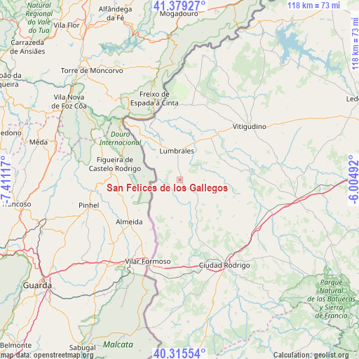
San Felices de los Gallegos GPS coordinates[2]
40° 50' 58.344" North, 6° 42' 28.944" West
| Map corner | latitude | longitude |
|---|---|---|
| Upper-left | 41.37927°, | -7.41117° |
| Center: | 40.84954°, | -6.70804° |
| Lower-right: | 40.31554°, | -6.00492° |
| Map W x H: | 118.3×118.3 km | = 73.5×73.5mi |
| max Lat: | 43.74134° ⇑55% North |
| San Felices de los Gallegos: | 40.84954° |
| min Lat: | ⇓45% South 27.64134° |
| min Long | San Felices de | max Long |
| -18.00367° | -6.70804° | 4.2899° |
| W 7.1%⇐ | ⇒92.9% E |
Elevation
Elevation of San Felices de los Gallegos is 668 m = 2192 ft, and this is 70 m = 230 ft above average elevation for this country.
| Max E: |
1682 m = 5518 ft | 49.1% |
| San Felices de los Gallegos | 668 m 2192 ft | |
| Avg. | 598 m = 1962 ft | |
Min E: |
0 m = 0 ft | 50.9% |
See also: Spain elevation on elevation.city.
Geographical zone
San Felices de los Gallegos is located in North temperate zone (between Tropic of Cancer and the Arctic Circle). Distance of this Northern Tropic circle is 1936.1 km =1203 mi to South.| Distance of | km | miles | from San Felices de los Gallegos |
|---|---|---|---|
| North Pole | 5465 | 3395.8 | to North |
| Arctic Circle | 2859.1 | 1776.6 | to North |
| Tropic Cancer | 1936.1 | 1203 | to South |
| Equator | 4542 | 2822.3 | to South |


Nearby cities:
15 places around San Felices de los Gallegos: (largest is in red/bold)
• Ahigal de los Aceiteros
4.1 km =2.5 mi,  307°
307°
• Aldea del Obispo
17.4 km =10.8 mi,  204°
204°
• Bañobárez
8 km =5 mi,  91°
91°
• Bermellar
16.9 km =10.5 mi,  10°
10°
• Bogajo
16.2 km =10.1 mi,  66°
66°
• Castillejo de Martín Viejo
17.9 km =11.1 mi,  160°
160°
• Cerralbo
17.1 km =10.6 mi,  36°
36°
• Hinojosa de Duero
16.9 km =10.5 mi,  334°
334°
• La Bouza
7.5 km =4.7 mi,  258°
258°
• Lumbrales
9.6 km =6 mi,  354°
354°
• Olmedo de Camaces
7.9 km =4.9 mi,  64°
64°
• Puerto Seguro
5.1 km =3.2 mi,  240°
240°
• Sobradillo
10.7 km =6.6 mi,  315°
315°
• Villar de Ciervo
12.7 km =7.9 mi,  191°
191°
• Villar de la Yegua
13.8 km =8.6 mi,  178°
178°
Sources, notices
• [Note1] Compared only with cities in Spain existing in our database
• [Src1] Map data: © OpenStreetMap contributors (CC-BY-SA)
• [Src2] Other city data from geonames.org with taken over terms of usage.
• [Src3] Geographical zone / Annual Mean Temperature by Robert A. Rohde @ Wikipedia
