Olmedo de Camaces geodata
Olmedo de Camaces (Castille and León) is a seat of a third-order administrative division; located in Spain in Europe/Madrid (GMT+2) time zone. With population of 137 people, there are 5525 cities with bigger population in this country. Compared to other cities in Spain, 54.3% of cities are located further ↑North; 92.1% of cities are located further →East and 55.2% of cities have lower elevation than Olmedo de Camaces. Note1
Administrative division(s):
- Level 1: Castille and León
- Level 2: Provincia de Salamanca
- Level 3: Olmedo de Camaces


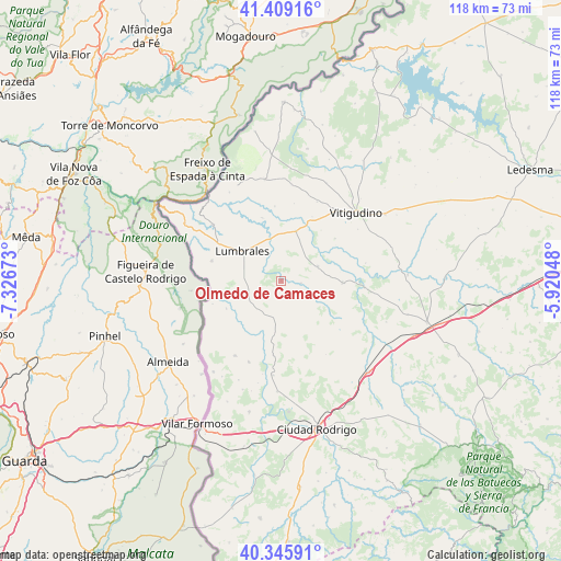
Olmedo de Camaces GPS coordinates[2]
40° 52' 46.812" North, 6° 37' 24.96" West
| Map corner | latitude | longitude |
|---|---|---|
| Upper-left | 41.40916°, | -7.32673° |
| Center: | 40.87967°, | -6.6236° |
| Lower-right: | 40.34591°, | -5.92048° |
| Map W x H: | 118.2×118.2 km | = 73.4×73.4mi |
| max Lat: | 43.74134° ⇑54.3% North |
| Olmedo de Camaces: | 40.87967° |
| min Lat: | ⇓45.7% South 27.64134° |
| min Long | Olmedo de Camac | max Long |
| -18.00367° | -6.6236° | 4.2899° |
| W 7.9%⇐ | ⇒92.1% E |
Elevation
Elevation of Olmedo de Camaces is 710 m = 2329 ft, and this is 112 m = 367 ft above average elevation for this country.
| Max E: |
1682 m = 5518 ft | 44.8% |
| Olmedo de Camaces | 710 m 2329 ft | |
| Avg. | 598 m = 1962 ft | |
Min E: |
0 m = 0 ft | 55.2% |
See also: Spain elevation on elevation.city.
Geographical zone
Olmedo de Camaces is located in North temperate zone (between Tropic of Cancer and the Arctic Circle). Distance of this Northern Tropic circle is 1939.5 km =1205.1 mi to South.| Distance of | km | miles | from Olmedo de Camaces |
|---|---|---|---|
| North Pole | 5461.7 | 3393.7 | to North |
| Arctic Circle | 2855.8 | 1774.5 | to North |
| Tropic Cancer | 1939.5 | 1205.1 | to South |
| Equator | 4545.4 | 2824.4 | to South |


Nearby cities:
15 places around Olmedo de Camaces: (largest is in red/bold)
• Ahigal de los Aceiteros
10.4 km =6.5 mi,  265°
265°
• Bañobárez
3.6 km =2.2 mi,  165°
165°
• Bermellar
13.9 km =8.6 mi,  343°
343°
• Bogajo
8.4 km =5.2 mi,  68°
68°
• Cerralbo
10.9 km =6.8 mi,  16°
16°
• La Bouza
15.2 km =9.4 mi,  251°
251°
• Lumbrales
10.1 km =6.3 mi,  307°
307°
• Pozos de Hinojo
18.2 km =11.3 mi,  78°
78°
• Puerto Seguro
13 km =8.1 mi,  243°
243°
• Saldeana
15.7 km =9.8 mi,  354°
354°
• San Felices de los Gallegos
7.9 km =4.9 mi, 244°
• Sobradillo
15.2 km =9.4 mi,  286°
286°
• Villares de Yeltes
17.8 km =11.1 mi,  94°
94°
• Villavieja de Yeltes
13.1 km =8.1 mi, 91°
• Yecla de Yeltes
14.4 km =8.9 mi,  51°
51°
Sources, notices
• [Note1] Compared only with cities in Spain existing in our database
• [Src1] Map data: © OpenStreetMap contributors (CC-BY-SA)
• [Src2] Other city data from geonames.org with taken over terms of usage.
• [Src3] Geographical zone / Annual Mean Temperature by Robert A. Rohde @ Wikipedia
