San Cristóbal de la Cuesta geodata
San Cristóbal de la Cuesta (Castille and León) is a seat of a third-order administrative division; located in Spain in Europe/Madrid (GMT+2) time zone. With population of 567 people, there are 3690 cities with bigger population in this country. Compared to other cities in Spain, 50.9% of cities are located further ↑North; 80.4% of cities are located further →East and 70.6% of cities have lower elevation than San Cristóbal de la Cuesta. Note1
Administrative division(s):
- Level 1: Castille and León
- Level 2: Provincia de Salamanca
- Level 3: San Cristóbal de la Cuesta
Current local time in San Cristóbal de la Cuesta:
10:45 PM, ThursdayDifference from your time zone: hours


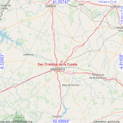
San Cristóbal de la Cuesta GPS coordinates[2]
41° 1' 45.084" North, 5° 37' 3.756" West
| Map corner | latitude | longitude |
|---|---|---|
| Upper-left | 41.55747°, | -6.32083° |
| Center: | 41.02919°, | -5.61771° |
| Lower-right: | 40.49664°, | -4.91458° |
| Map W x H: | 118×118 km | = 73.3×73.3mi |
| max Lat: | 43.74134° ⇑50.9% North |
| San Cristóbal de la Cuesta: | 41.02919° |
| min Lat: | ⇓49.1% South 27.64134° |
| min Long | San Cristóbal | max Long |
| -18.00367° | -5.61771° | 4.2899° |
| W 19.6%⇐ | ⇒80.4% E |
Elevation
Elevation of San Cristóbal de la Cuesta is 818 m = 2684 ft, and this is 220 m = 722 ft above average elevation for this country.
| Max E: |
1682 m = 5518 ft | 29.4% |
| San Cristóbal de la Cuesta | 818 m 2684 ft | |
| Avg. | 598 m = 1962 ft | |
Min E: |
0 m = 0 ft | 70.6% |
See also: Spain elevation on elevation.city.
Geographical zone
San Cristóbal de la Cuesta is located in North temperate zone (between Tropic of Cancer and the Arctic Circle). Distance of this Northern Tropic circle is 1956.1 km =1215.5 mi to South.| Distance of | km | miles | from San Cristóbal de la Cuesta |
|---|---|---|---|
| North Pole | 5445 | 3383.4 | to North |
| Arctic Circle | 2839.2 | 1764.2 | to North |
| Tropic Cancer | 1956.1 | 1215.5 | to South |
| Equator | 4562 | 2834.7 | to South |


Nearby cities:
15 places around San Cristóbal de la Cuesta: (largest is in red/bold)
• Aldealengua
7.9 km =4.9 mi,  133°
133°
• Arcediano
8.6 km =5.3 mi,  33°
33°
• Cabrerizos
5.7 km =3.5 mi,  172°
172°
• Castellanos de Moriscos
2.5 km =1.6 mi,  116°
116°
• Castellanos de Villiquera
6.9 km =4.3 mi,  290°
290°
• Gomecello
7 km =4.3 mi,  77°
77°
• Monterrubio de Armuña
2.2 km =1.4 mi,  262°
262°
• Moriscos
3.8 km =2.4 mi, 127°
• Negrilla de Palencia
7.3 km =4.5 mi,  17°
17°
• Palencia de Negrilla
7.4 km =4.6 mi,  10°
10°
• Pedrosillo el Ralo
7 km =4.3 mi,  57°
57°
• Salamanca
7.8 km =4.8 mi,  209°
209°
• Valdunciel
7.7 km =4.8 mi,  323°
323°
• Villamayor
7.3 km =4.5 mi,  243°
243°
• Villares de la Reina
3.5 km =2.2 mi,  228°
228°
Sources, notices
• [Note1] Compared only with cities in Spain existing in our database
• [Src1] Map data: © OpenStreetMap contributors (CC-BY-SA)
• [Src2] Other city data from geonames.org with taken over terms of usage.
• [Src3] Geographical zone / Annual Mean Temperature by Robert A. Rohde @ Wikipedia
