Aldealengua geodata
Aldealengua (Castille and León) is a seat of a third-order administrative division; located in Spain in Europe/Madrid (GMT+2) time zone. With population of 561 people, there are 3714 cities with bigger population in this country. Compared to other cities in Spain, 52% of cities are located further ↑North; 79.4% of cities are located further →East and 66.1% of cities have lower elevation than Aldealengua. Note1
Administrative division(s):
- Level 1: Castille and León
- Level 2: Provincia de Salamanca
- Level 3: Aldealengua


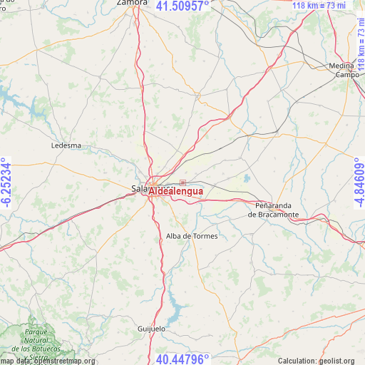
Aldealengua GPS coordinates[2]
40° 58' 51.24" North, 5° 32' 57.192" West
| Map corner | latitude | longitude |
|---|---|---|
| Upper-left | 41.50957°, | -6.25234° |
| Center: | 40.9809°, | -5.54922° |
| Lower-right: | 40.44796°, | -4.84609° |
| Map W x H: | 118×118 km | = 73.3×73.3mi |
| max Lat: | 43.74134° ⇑52% North |
| Aldealengua: | 40.9809° |
| min Lat: | ⇓48% South 27.64134° |
| min Long | Aldealengua | max Long |
| -18.00367° | -5.54922° | 4.2899° |
| W 20.6%⇐ | ⇒79.4% E |
Elevation
Elevation of Aldealengua is 785 m = 2575 ft, and this is 187 m = 614 ft above average elevation for this country.
| Max E: |
1682 m = 5518 ft | 33.9% |
| Aldealengua | 785 m 2575 ft | |
| Avg. | 598 m = 1962 ft | |
Min E: |
0 m = 0 ft | 66.1% |
See also: Spain elevation on elevation.city.
Geographical zone
Aldealengua is located in North temperate zone (between Tropic of Cancer and the Arctic Circle). Distance of this Northern Tropic circle is 1950.7 km =1212.1 mi to South.| Distance of | km | miles | from Aldealengua |
|---|---|---|---|
| North Pole | 5450.4 | 3386.7 | to North |
| Arctic Circle | 2844.5 | 1767.5 | to North |
| Tropic Cancer | 1950.7 | 1212.1 | to South |
| Equator | 4556.6 | 2831.3 | to South |


Nearby cities:
15 places around Aldealengua: (largest is in red/bold)
• Aldearrubia
5.2 km =3.2 mi,  54°
54°
• Cabezabellosa de la Calzada
8.7 km =5.4 mi,  35°
35°
• Cabrerizos
5 km =3.1 mi,  266°
266°
• Calvarrasa de Abajo
3.8 km =2.4 mi,  184°
184°
• Castellanos de Moriscos
5.5 km =3.4 mi,  320°
320°
• Encinas de Abajo
8.4 km =5.2 mi,  127°
127°
• Gomecello
7 km =4.3 mi,  9°
9°
• Huerta
7 km =4.3 mi,  101°
101°
• Machacón
6.4 km =4 mi,  161°
161°
• Moriscos
4.1 km =2.5 mi, 317°
• Pelabravo
5.5 km =3.4 mi,  207°
207°
• San Cristóbal de la Cuesta
7.9 km =4.9 mi,  313°
313°
• San Morales
4.2 km =2.6 mi,  70°
70°
• Santa Marta de Tormes
7.4 km =4.6 mi,  242°
242°
• Villares de la Reina
8.9 km =5.5 mi,  290°
290°
Sources, notices
• [Note1] Compared only with cities in Spain existing in our database
• [Src1] Map data: © OpenStreetMap contributors (CC-BY-SA)
• [Src2] Other city data from geonames.org with taken over terms of usage.
• [Src3] Geographical zone / Annual Mean Temperature by Robert A. Rohde @ Wikipedia
