Gomecello geodata
Gomecello (Castille and León) is a seat of a third-order administrative division; located in Spain in Europe/Madrid (GMT+2) time zone. With population of 509 people, there are 3858 cities with bigger population in this country. Compared to other cities in Spain, 50.5% of cities are located further ↑North; 79.2% of cities are located further →East and 74.1% of cities have lower elevation than Gomecello. Note1
Administrative division(s):
- Level 1: Castille and León
- Level 2: Provincia de Salamanca
- Level 3: Gomecello


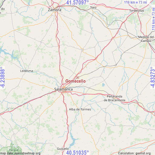
Gomecello GPS coordinates[2]
41° 2' 34.08" North, 5° 32' 9.06" West
| Map corner | latitude | longitude |
|---|---|---|
| Upper-left | 41.57097°, | -6.23898° |
| Center: | 41.0428°, | -5.53585° |
| Lower-right: | 40.51035°, | -4.83273° |
| Map W x H: | 117.9×117.9 km | = 73.3×73.3mi |
| max Lat: | 43.74134° ⇑50.5% North |
| Gomecello: | 41.0428° |
| min Lat: | ⇓49.5% South 27.64134° |
| min Long | Gomecello | max Long |
| -18.00367° | -5.53585° | 4.2899° |
| W 20.8%⇐ | ⇒79.2% E |
Elevation
Elevation of Gomecello is 844 m = 2769 ft, and this is 246 m = 807 ft above average elevation for this country.
| Max E: |
1682 m = 5518 ft | 25.9% |
| Gomecello | 844 m 2769 ft | |
| Avg. | 598 m = 1962 ft | |
Min E: |
0 m = 0 ft | 74.1% |
See also: Spain elevation on elevation.city.
Geographical zone
Gomecello is located in North temperate zone (between Tropic of Cancer and the Arctic Circle). Distance of this Northern Tropic circle is 1957.6 km =1216.4 mi to South.| Distance of | km | miles | from Gomecello |
|---|---|---|---|
| North Pole | 5443.5 | 3382.4 | to North |
| Arctic Circle | 2837.6 | 1763.2 | to North |
| Tropic Cancer | 1957.6 | 1216.4 | to South |
| Equator | 4563.5 | 2835.6 | to South |


Nearby cities:
15 places around Gomecello: (largest is in red/bold)
• Aldealengua
7 km =4.3 mi,  189°
189°
• Aldearrubia
5 km =3.1 mi,  140°
140°
• Arcediano
6 km =3.7 mi,  339°
339°
• Cabezabellosa de la Calzada
4 km =2.5 mi,  88°
88°
• Castellanos de Moriscos
5.3 km =3.3 mi,  240°
240°
• Moriscos
5.4 km =3.4 mi,  225°
225°
• Negrilla de Palencia
7.2 km =4.5 mi,  319°
319°
• Pajares de la Laguna
5.5 km =3.4 mi,  24°
24°
• Palencia de Negrilla
8 km =5 mi, 316°
• Pedrosillo el Ralo
2.5 km =1.6 mi, 335°
• Pitiegua
6.2 km =3.9 mi,  69°
69°
• San Cristóbal de la Cuesta
7 km =4.3 mi,  257°
257°
• San Morales
6.2 km =3.9 mi,  152°
152°
• Tardáguila
8.6 km =5.3 mi, 338°
• Villaverde de Guareña
2.5 km =1.6 mi, 21°
Sources, notices
• [Note1] Compared only with cities in Spain existing in our database
• [Src1] Map data: © OpenStreetMap contributors (CC-BY-SA)
• [Src2] Other city data from geonames.org with taken over terms of usage.
• [Src3] Geographical zone / Annual Mean Temperature by Robert A. Rohde @ Wikipedia
