Sant Adrià de Besòs geodata
Sant Adrià de Besòs (Catalonia) is a populated place; located in Spain in Europe/Madrid (GMT+2) time zone. With population of 33,761 people, there are 265 cities with bigger population in this country. Compared to other cities in Spain, 58.9% of cities are located further ↓South; 95.4% of cities are located further ←West and 96.6% of cities have higher elevation than Sant Adrià de Besòs. Note1


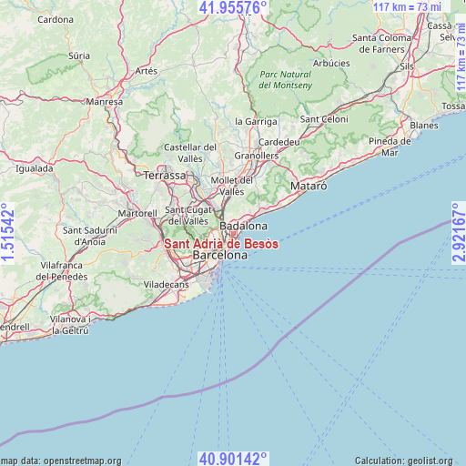
Sant Adrià de Besòs GPS coordinates[2]
41° 25' 50.628" North, 2° 13' 6.78" East
| Map corner | latitude | longitude |
|---|---|---|
| Upper-left | 41.95576°, | 1.51542° |
| Center: | 41.43073°, | 2.21855° |
| Lower-right: | 40.90142°, | 2.92167° |
| Map W x H: | 117.2×117.2 km | = 72.8×72.8mi |
| max Lat: | 43.74134° ⇑41.1% North |
| Sant Adrià de Besòs: | 41.43073° |
| min Lat: | ⇓58.9% South 27.64134° |
| min Long | Sant Adrià de | max Long |
| -18.00367° | 2.21855° | 4.2899° |
| W 95.4%⇐ | ⇒4.6% E |
Elevation
Elevation of Sant Adrià de Besòs is 17 m = 56 ft, and this is 581 m = 1906 ft below average elevation for this country.
| Max E: |
1682 m = 5518 ft | 96.6% |
| Avg. | 598 m = 1962 ft | |
| Sant Adrià de Besòs | 17 m = 56 ft | |
Min E: |
0 m = 0 ft | 3.4% |
See also: Spain elevation on elevation.city.
Geographical zone
Sant Adrià de Besòs is located in North temperate zone (between Tropic of Cancer and the Arctic Circle). Distance of this Northern Tropic circle is 2000.7 km =1243.2 mi to South.| Distance of | km | miles | from Sant Adrià de Besòs |
|---|---|---|---|
| North Pole | 5400.4 | 3355.7 | to North |
| Arctic Circle | 2794.5 | 1736.4 | to North |
| Tropic Cancer | 2000.7 | 1243.2 | to South |
| Equator | 4606.7 | 2862.5 | to South |


Nearby cities:
15 places around Sant Adrià de Besòs: (largest is in red/bold)
• Badalona
3.2 km =2 mi,  48°
48°
• Barri de Sant Andreu
2.5 km =1.6 mi,  286°
286°
• Baró de Viver
2.3 km =1.4 mi,  315°
315°
• Diagonal Mar
2.4 km =1.5 mi,  184°
184°
• La Sagrera
2.9 km =1.8 mi,  251°
251°
• Llefià
0.8 km =0.5 mi,  5°
5°
• Navas
3.1 km =1.9 mi,  242°
242°
• Provenals del Poblenou
2.6 km =1.6 mi,  211°
211°
• Sant Andreu
2.5 km =1.6 mi,  282°
282°
• Sant Martí
2.1 km =1.3 mi,  228°
228°
• Sant Martí de Provençals
2.2 km =1.4 mi, 237°
• Santa Coloma de Gramenet
2.5 km =1.6 mi,  339°
339°
• el Besòs i el Maresme
2 km =1.2 mi, 182°
• el Bon Pastor
1.6 km =1 mi,  296°
296°
• la Verneda i la Pau
1.5 km =0.9 mi, 239°
Sources, notices
• [Note1] Compared only with cities in Spain existing in our database
• [Src1] Map data: © OpenStreetMap contributors (CC-BY-SA)
• [Src2] Other city data from geonames.org with taken over terms of usage.
• [Src3] Geographical zone / Annual Mean Temperature by Robert A. Rohde @ Wikipedia
