Llefià geodata
Llefià (Catalonia) is a populated place; located in Spain in Europe/Madrid (GMT+2) time zone. With population of 43,827 people, there are 198 cities with bigger population in this country. Compared to other cities in Spain, 59.2% of cities are located further ↓South; 95.5% of cities are located further ←West and 95.4% of cities have higher elevation than Llefià. Note1


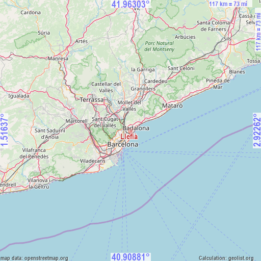
Llefià GPS coordinates[2]
41° 26' 17.016" North, 2° 13' 10.2" East
| Map corner | latitude | longitude |
|---|---|---|
| Upper-left | 41.96303°, | 1.51637° |
| Center: | 41.43806°, | 2.2195° |
| Lower-right: | 40.90881°, | 2.92262° |
| Map W x H: | 117.2×117.2 km | = 72.8×72.8mi |
| max Lat: | 43.74134° ⇑40.8% North |
| Llefià: | 41.43806° |
| min Lat: | ⇓59.2% South 27.64134° |
| min Long | Llefià | max Long |
| -18.00367° | 2.2195° | 4.2899° |
| W 95.5%⇐ | ⇒4.5% E |
Elevation
Elevation of Llefià is 23 m = 75 ft, and this is 575 m = 1886 ft below average elevation for this country.
| Max E: |
1682 m = 5518 ft | 95.4% |
| Avg. | 598 m = 1962 ft | |
| Llefià | 23 m = 75 ft | |
Min E: |
0 m = 0 ft | 4.6% |
See also: Llefià elevation on elevation.city.
Geographical zone
Llefià is located in North temperate zone (between Tropic of Cancer and the Arctic Circle). Distance of this Northern Tropic circle is 2001.6 km =1243.7 mi to South.| Distance of | km | miles | from Llefià |
|---|---|---|---|
| North Pole | 5399.6 | 3355.2 | to North |
| Arctic Circle | 2793.7 | 1735.9 | to North |
| Tropic Cancer | 2001.6 | 1243.7 | to South |
| Equator | 4607.5 | 2863 | to South |


Nearby cities:
15 places around Llefià: (largest is in red/bold)
• Badalona
2.7 km =1.7 mi,  60°
60°
• Barri de Sant Andreu
2.4 km =1.5 mi,  267°
267°
• Baró de Viver
1.9 km =1.2 mi,  296°
296°
• Diagonal Mar
3.2 km =2 mi,  184°
184°
• Sant Adrià de Besòs
0.8 km =0.5 mi,  185°
185°
• Sant Andreu
2.5 km =1.6 mi,  263°
263°
• Sant Martí
2.8 km =1.7 mi,  217°
217°
• Sant Martí de Provençals
2.8 km =1.7 mi, 224°
• Santa Coloma de Gramenet
1.8 km =1.1 mi,  327°
327°
• el Besòs i el Maresme
2.8 km =1.7 mi, 183°
• el Bon Pastor
1.5 km =0.9 mi, 265°
• la Prosperitat
3.2 km =2 mi,  279°
279°
• la Trinitat Nova
3.2 km =2 mi, 295°
• la Trinitat Vella
2.7 km =1.7 mi, 304°
• la Verneda i la Pau
2.1 km =1.3 mi, 221°
Sources, notices
• [Note1] Compared only with cities in Spain existing in our database
• [Src1] Map data: © OpenStreetMap contributors (CC-BY-SA)
• [Src2] Other city data from geonames.org with taken over terms of usage.
• [Src3] Geographical zone / Annual Mean Temperature by Robert A. Rohde @ Wikipedia
