la Verneda i la Pau geodata
la Verneda i la Pau (Catalonia) is a section of populated place; located in Spain in Europe/Madrid (GMT+2) time zone. With population of 29,013 people, there are 322 cities with bigger population in this country. Compared to other cities in Spain, 58.7% of cities are located further ↓South; 95.3% of cities are located further ←West and 94.7% of cities have higher elevation than la Verneda i la Pau. Note1
Administrative division(s):
- Level 1: Catalonia
- Level 2: Província de Barcelona
- Level 3: Barcelona
- Level 4: Sant Martí


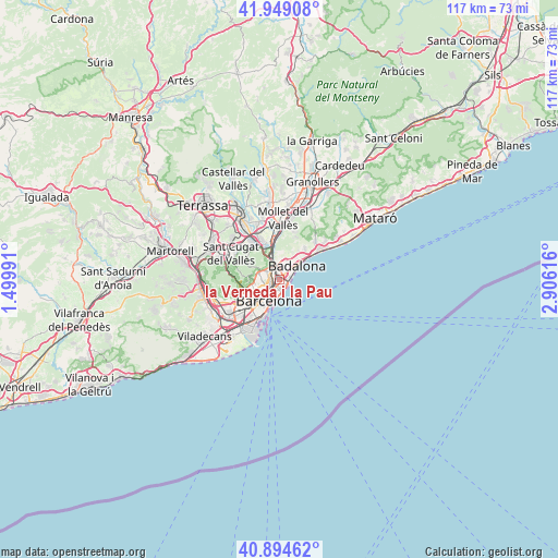
la Verneda i la Pau GPS coordinates[2]
41° 25' 26.364" North, 2° 12' 10.944" East
| Map corner | latitude | longitude |
|---|---|---|
| Upper-left | 41.94908°, | 1.49991° |
| Center: | 41.42399°, | 2.20304° |
| Lower-right: | 40.89462°, | 2.90616° |
| Map W x H: | 117.2×117.2 km | = 72.8×72.8mi |
| max Lat: | 43.74134° ⇑41.3% North |
| la Verneda i la Pau: | 41.42399° |
| min Lat: | ⇓58.7% South 27.64134° |
| min Long | la Verneda i la | max Long |
| -18.00367° | 2.20304° | 4.2899° |
| W 95.3%⇐ | ⇒4.7% E |
Elevation
Elevation of la Verneda i la Pau is 26 m = 85 ft, and this is 572 m = 1877 ft below average elevation for this country.
| Max E: |
1682 m = 5518 ft | 94.7% |
| Avg. | 598 m = 1962 ft | |
| la Verneda i la Pau | 26 m = 85 ft | |
Min E: |
0 m = 0 ft | 5.3% |
See also: Spain elevation on elevation.city.
Geographical zone
la Verneda i la Pau is located in North temperate zone (between Tropic of Cancer and the Arctic Circle). Distance of this Northern Tropic circle is 2000 km =1242.7 mi to South.| Distance of | km | miles | from la Verneda i la Pau |
|---|---|---|---|
| North Pole | 5401.1 | 3356.1 | to North |
| Arctic Circle | 2795.3 | 1736.9 | to North |
| Tropic Cancer | 2000 | 1242.7 | to South |
| Equator | 4605.9 | 2862 | to South |


Nearby cities:
15 places around la Verneda i la Pau: (largest is in red/bold)
• Barri de Sant Andreu
1.8 km =1.1 mi,  323°
323°
• Diagonal Mar
2 km =1.2 mi,  146°
146°
• La Sagrera
1.4 km =0.9 mi,  264°
264°
• Llefià
2.1 km =1.3 mi,  41°
41°
• Navas
1.6 km =1 mi,  245°
245°
• Provenals del Poblenou
1.4 km =0.9 mi,  181°
181°
• Sant Adrià de Besòs
1.5 km =0.9 mi,  59°
59°
• Sant Andreu
1.7 km =1.1 mi, 319°
• Sant Martí
0.7 km =0.4 mi,  205°
205°
• Sant Martí de Provençals
0.7 km =0.4 mi,  233°
233°
• el Besòs i el Maresme
1.7 km =1.1 mi,  135°
135°
• el Bon Pastor
1.5 km =0.9 mi,  355°
355°
• el Clot
1.9 km =1.2 mi, 213°
• el Congrés i els Indians
1.9 km =1.2 mi,  272°
272°
• el Poblenou
2.2 km =1.4 mi, 177°
Sources, notices
• [Note1] Compared only with cities in Spain existing in our database
• [Src1] Map data: © OpenStreetMap contributors (CC-BY-SA)
• [Src2] Other city data from geonames.org with taken over terms of usage.
• [Src3] Geographical zone / Annual Mean Temperature by Robert A. Rohde @ Wikipedia
