Vallanca geodata
Vallanca (Valencia) is a seat of a third-order administrative division; located in Spain in Europe/Madrid (GMT+2) time zone. With population of 190 people, there are 5108 cities with bigger population in this country. Compared to other cities in Spain, 69.2% of cities are located further ↑North; 74.4% of cities are located further ←West and 92.2% of cities have lower elevation than Vallanca. Note1


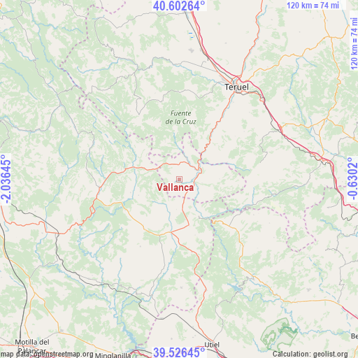
Vallanca GPS coordinates[2]
40° 4' 0.012" North, 1° 19' 59.988" West
| Map corner | latitude | longitude |
|---|---|---|
| Upper-left | 40.60264°, | -2.03645° |
| Center: | 40.06667°, | -1.33333° |
| Lower-right: | 39.52645°, | -0.6302° |
| Map W x H: | 119.7×119.7 km | = 74.4×74.4mi |
| max Lat: | 43.74134° ⇑69.2% North |
| Vallanca: | 40.06667° |
| min Lat: | ⇓30.8% South 27.64134° |
| min Long | Vallanca | max Long |
| -18.00367° | -1.33333° | 4.2899° |
| W 74.4%⇐ | ⇒25.6% E |
Elevation
Elevation of Vallanca is 1073 m = 3520 ft, and this is 475 m = 1558 ft above average elevation for this country.
| Max E: |
1682 m = 5518 ft | 7.8% |
| Vallanca | 1073 m 3520 ft | |
| Avg. | 598 m = 1962 ft | |
Min E: |
0 m = 0 ft | 92.2% |
See also: Spain elevation on elevation.city.
Geographical zone
Vallanca is located in North temperate zone (between Tropic of Cancer and the Arctic Circle). Distance of this Northern Tropic circle is 1849.1 km =1149 mi to South.| Distance of | km | miles | from Vallanca |
|---|---|---|---|
| North Pole | 5552.1 | 3449.9 | to North |
| Arctic Circle | 2946.2 | 1830.7 | to North |
| Tropic Cancer | 1849.1 | 1149 | to South |
| Equator | 4455 | 2768.2 | to South |


Nearby cities:
15 places around Vallanca: (largest is in red/bold)
• Ademuz
4 km =2.5 mi,  98°
98°
• Alcalá de la Vega
16 km =9.9 mi,  256°
256°
• Algarra
11.3 km =7 mi,  228°
228°
• Alobras
13.6 km =8.5 mi,  340°
340°
• Casas Altas
6.8 km =4.2 mi,  123°
123°
• Casas Bajas
7.9 km =4.9 mi,  134°
134°
• Casas de Garcimolina
10.3 km =6.4 mi,  223°
223°
• Castielfabib
7.6 km =4.7 mi,  19°
19°
• Libros
13.7 km =8.5 mi,  38°
38°
• Moya
13.3 km =8.3 mi,  192°
192°
• Salvacañete
14.7 km =9.1 mi,  284°
284°
• Santa Cruz de Moya
14.2 km =8.8 mi,  156°
156°
• Tormón
15.2 km =9.4 mi,  353°
353°
• Tramacastiel
15.7 km =9.8 mi,  30°
30°
• Veguillas de la Sierra
10.9 km =6.8 mi,  328°
328°
Sources, notices
• [Note1] Compared only with cities in Spain existing in our database
• [Src1] Map data: © OpenStreetMap contributors (CC-BY-SA)
• [Src2] Other city data from geonames.org with taken over terms of usage.
• [Src3] Geographical zone / Annual Mean Temperature by Robert A. Rohde @ Wikipedia
