Salt geodata
Salt (Catalonia) is a seat of a third-order administrative division; located in Spain in Europe/Madrid (GMT+2) time zone. With population of 29,985 people, there are 306 cities with bigger population in this country. Compared to other cities in Spain, 73% of cities are located further ↓South; 97.6% of cities are located further ←West and 88.6% of cities have higher elevation than Salt. Note1


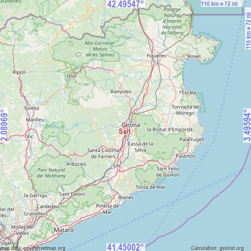
Salt GPS coordinates[2]
41° 58' 29.604" North, 2° 47' 34.116" East
| Map corner | latitude | longitude |
|---|---|---|
| Upper-left | 42.49547°, | 2.08969° |
| Center: | 41.97489°, | 2.79281° |
| Lower-right: | 41.45002°, | 3.49594° |
| Map W x H: | 116.2×116.2 km | = 72.2×72.2mi |
| max Lat: | 43.74134° ⇑27% North |
| Salt: | 41.97489° |
| min Lat: | ⇓73% South 27.64134° |
| min Long | Salt | max Long |
| -18.00367° | 2.79281° | 4.2899° |
| W 97.6%⇐ | ⇒2.4% E |
Elevation
Elevation of Salt is 86 m = 282 ft, and this is 512 m = 1680 ft below average elevation for this country.
| Max E: |
1682 m = 5518 ft | 88.6% |
| Avg. | 598 m = 1962 ft | |
| Salt | 86 m = 282 ft | |
Min E: |
0 m = 0 ft | 11.4% |
See also: Spain elevation on elevation.city.
Geographical zone
Salt is located in North temperate zone (between Tropic of Cancer and the Arctic Circle). Distance of this Northern Tropic circle is 2061.3 km =1280.8 mi to South.| Distance of | km | miles | from Salt |
|---|---|---|---|
| North Pole | 5339.9 | 3318.1 | to North |
| Arctic Circle | 2734 | 1698.8 | to North |
| Tropic Cancer | 2061.3 | 1280.8 | to South |
| Equator | 4667.2 | 2900.1 | to South |


Nearby cities:
15 places around Salt: (largest is in red/bold)
• Aiguaviva
4.8 km =3 mi,  211°
211°
• Bescanó
4.5 km =2.8 mi,  257°
257°
• Celrà
9.9 km =6.2 mi,  49°
49°
• Fornells de la Selva
5 km =3.1 mi,  164°
164°
• Girona
2.8 km =1.7 mi,  71°
71°
• Juià
11.2 km =7 mi, 65°
• Llambilles
7.7 km =4.8 mi,  141°
141°
• Palol de Revardit
10.2 km =6.3 mi,  3°
3°
• Quart d’Onyar
5.5 km =3.4 mi,  133°
133°
• Riudellots de la Selva
9.1 km =5.7 mi,  173°
173°
• Sant Gregori
5 km =3.1 mi,  280°
280°
• Sant Julià de Ramis
7.9 km =4.9 mi,  39°
39°
• Sarrià de Ter
5.7 km =3.5 mi, 35°
• Vilablareix
2.5 km =1.6 mi,  219°
219°
• Vilobí d'Onyar
10.8 km =6.7 mi,  199°
199°
Sources, notices
• [Note1] Compared only with cities in Spain existing in our database
• [Src1] Map data: © OpenStreetMap contributors (CC-BY-SA)
• [Src2] Other city data from geonames.org with taken over terms of usage.
• [Src3] Geographical zone / Annual Mean Temperature by Robert A. Rohde @ Wikipedia
