Aiguaviva geodata
Aiguaviva (Catalonia) is a seat of a third-order administrative division; located in Spain in Europe/Madrid (GMT+2) time zone. With population of 608 people, there are 3595 cities with bigger population in this country. Compared to other cities in Spain, 72% of cities are located further ↓South; 97.4% of cities are located further ←West and 83.8% of cities have higher elevation than Aiguaviva. Note1


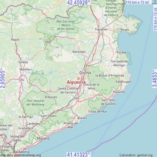
Aiguaviva GPS coordinates[2]
41° 56' 18.24" North, 2° 45' 43.812" East
| Map corner | latitude | longitude |
|---|---|---|
| Upper-left | 42.45928°, | 2.05905° |
| Center: | 41.9384°, | 2.76217° |
| Lower-right: | 41.41323°, | 3.4653° |
| Map W x H: | 116.3×116.3 km | = 72.3×72.3mi |
| max Lat: | 43.74134° ⇑28% North |
| Aiguaviva: | 41.9384° |
| min Lat: | ⇓72% South 27.64134° |
| min Long | Aiguaviva | max Long |
| -18.00367° | 2.76217° | 4.2899° |
| W 97.4%⇐ | ⇒2.6% E |
Elevation
Elevation of Aiguaviva is 158 m = 518 ft, and this is 440 m = 1444 ft below average elevation for this country.
| Max E: |
1682 m = 5518 ft | 83.8% |
| Avg. | 598 m = 1962 ft | |
| Aiguaviva | 158 m = 518 ft | |
Min E: |
0 m = 0 ft | 16.2% |
See also: Spain elevation on elevation.city.
Geographical zone
Aiguaviva is located in North temperate zone (between Tropic of Cancer and the Arctic Circle). Distance of this Northern Tropic circle is 2057.2 km =1278.3 mi to South.| Distance of | km | miles | from Aiguaviva |
|---|---|---|---|
| North Pole | 5343.9 | 3320.5 | to North |
| Arctic Circle | 2738.1 | 1701.4 | to North |
| Tropic Cancer | 2057.2 | 1278.3 | to South |
| Equator | 4663.1 | 2897.5 | to South |


Nearby cities:
15 places around Aiguaviva: (largest is in red/bold)
• Anglès
10.6 km =6.6 mi,  280°
280°
• Bescanó
3.6 km =2.2 mi,  328°
328°
• Brunyola
7.8 km =4.8 mi,  236°
236°
• Cassà de la Selva
10.9 km =6.8 mi,  121°
121°
• Fornells de la Selva
4 km =2.5 mi,  101°
101°
• Girona
7.2 km =4.5 mi,  46°
46°
• Llambilles
7.6 km =4.7 mi, 104°
• Quart d’Onyar
6.5 km =4 mi,  87°
87°
• Riudellots de la Selva
6.1 km =3.8 mi,  145°
145°
• Salt
4.8 km =3 mi,  31°
31°
• Sant Andreu Salou
9.9 km =6.2 mi,  143°
143°
• Sant Gregori
5.5 km =3.4 mi, 334°
• Sarrià de Ter
10.5 km =6.5 mi, 34°
• Vilablareix
2.3 km =1.4 mi,  24°
24°
• Vilobí d'Onyar
6.2 km =3.9 mi,  189°
189°
Sources, notices
• [Note1] Compared only with cities in Spain existing in our database
• [Src1] Map data: © OpenStreetMap contributors (CC-BY-SA)
• [Src2] Other city data from geonames.org with taken over terms of usage.
• [Src3] Geographical zone / Annual Mean Temperature by Robert A. Rohde @ Wikipedia
