Salcedillo geodata
Salcedillo (Aragon) is a seat of a third-order administrative division; located in Spain in Europe/Madrid (GMT+2) time zone. With population of 8 people, there are 6760 cities with bigger population in this country. Compared to other cities in Spain, 52.5% of cities are located further ↑North; 77.1% of cities are located further ←West and 96.6% of cities have lower elevation than Salcedillo. Note1


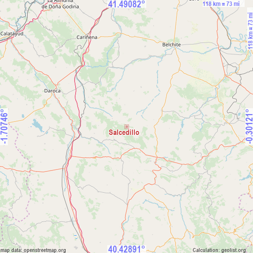
Salcedillo GPS coordinates[2]
40° 57' 43.2" North, 1° 0' 15.588" West
| Map corner | latitude | longitude |
|---|---|---|
| Upper-left | 41.49082°, | -1.70746° |
| Center: | 40.962°, | -1.00433° |
| Lower-right: | 40.42891°, | -0.30121° |
| Map W x H: | 118.1×118.1 km | = 73.4×73.4mi |
| max Lat: | 43.74134° ⇑52.5% North |
| Salcedillo: | 40.962° |
| min Lat: | ⇓47.5% South 27.64134° |
| min Long | Salcedillo | max Long |
| -18.00367° | -1.00433° | 4.2899° |
| W 77.1%⇐ | ⇒22.9% E |
Elevation
Elevation of Salcedillo is 1194 m = 3917 ft, and this is 596 m = 1955 ft above average elevation for this country.
| Max E: |
1682 m = 5518 ft | 3.4% |
| Salcedillo | 1194 m 3917 ft | |
| Avg. | 598 m = 1962 ft | |
Min E: |
0 m = 0 ft | 96.6% |
See also: Spain elevation on elevation.city.
Geographical zone
Salcedillo is located in North temperate zone (between Tropic of Cancer and the Arctic Circle). Distance of this Northern Tropic circle is 1948.6 km =1210.8 mi to South.| Distance of | km | miles | from Salcedillo |
|---|---|---|---|
| North Pole | 5452.5 | 3388 | to North |
| Arctic Circle | 2846.6 | 1768.8 | to North |
| Tropic Cancer | 1948.6 | 1210.8 | to South |
| Equator | 4554.5 | 2830 | to South |


Nearby cities:
15 places around Salcedillo: (largest is in red/bold)
• Allueva
4.1 km =2.5 mi,  308°
308°
• Anadón
2.8 km =1.7 mi,  37°
37°
• Barrachina
13.4 km =8.3 mi,  237°
237°
• Blesa
14.1 km =8.8 mi,  45°
45°
• Fonfría
7.7 km =4.8 mi,  299°
299°
• Fuenferrada
10.3 km =6.4 mi,  183°
183°
• Huesa del Común
9 km =5.6 mi, 53°
• Loscos
13.7 km =8.5 mi,  345°
345°
• Maicas
9.6 km =6 mi,  86°
86°
• Monforte de Moyuela
10.4 km =6.5 mi,  355°
355°
• Plou
13 km =8.1 mi,  74°
74°
• Segura de los Baños
5 km =3.1 mi,  117°
117°
• Torrecilla del Rebollar
8.2 km =5.1 mi,  224°
224°
• Villanueva del Rebollar de la Sierra
7.9 km =4.9 mi, 182°
• Vivel del Río Martín
11.5 km =7.1 mi,  151°
151°
Sources, notices
• [Note1] Compared only with cities in Spain existing in our database
• [Src1] Map data: © OpenStreetMap contributors (CC-BY-SA)
• [Src2] Other city data from geonames.org with taken over terms of usage.
• [Src3] Geographical zone / Annual Mean Temperature by Robert A. Rohde @ Wikipedia
