Torrecilla del Rebollar geodata
Torrecilla del Rebollar (Aragon) is a seat of a third-order administrative division; located in Spain in Europe/Madrid (GMT+2) time zone. With population of 173 people, there are 5237 cities with bigger population in this country. Compared to other cities in Spain, 53.6% of cities are located further ↑North; 76.6% of cities are located further ←West and 95.3% of cities have lower elevation than Torrecilla del Rebollar. Note1
Administrative division(s):
- Level 1: Aragon
- Level 2: Provincia de Teruel
- Level 3: Torrecilla del Rebollar
Current local time in Torrecilla del Rebollar:
10:54 PM, ThursdayDifference from your time zone: hours


Torrecilla del Rebollar GPS coordinates[2]
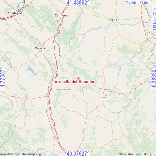
40° 54' 35.208" North, 1° 4' 20.784" West
| Map corner | latitude | longitude |
|---|---|---|
| Upper-left | 41.43902°, | -1.77557° |
| Center: | 40.90978°, | -1.07244° |
| Lower-right: | 40.37627°, | -0.36932° |
| Map W x H: | 118.2×118.2 km | = 73.4×73.4mi |
| max Lat: | 43.74134° ⇑53.6% North |
| Torrecilla del Rebollar: | 40.90978° |
| min Lat: | ⇓46.4% South 27.64134° |
| min Long | Torrecilla del | max Long |
| -18.00367° | -1.07244° | 4.2899° |
| W 76.6%⇐ | ⇒23.4% E |
Elevation
Elevation of Torrecilla del Rebollar is 1145 m = 3757 ft, and this is 547 m = 1795 ft above average elevation for this country.
| Max E: |
1682 m = 5518 ft | 4.7% |
| Torrecilla del Rebollar | 1145 m 3757 ft | |
| Avg. | 598 m = 1962 ft | |
Min E: |
0 m = 0 ft | 95.3% |
See also: Spain elevation on elevation.city.
Geographical zone
Torrecilla del Rebollar is located in North temperate zone (between Tropic of Cancer and the Arctic Circle). Distance of this Northern Tropic circle is 1942.8 km =1207.2 mi to South.| Distance of | km | miles | from Torrecilla del Rebollar |
|---|---|---|---|
| North Pole | 5458.3 | 3391.6 | to North |
| Arctic Circle | 2852.4 | 1772.4 | to North |
| Tropic Cancer | 1942.8 | 1207.2 | to South |
| Equator | 4548.7 | 2826.4 | to South |


Nearby cities:
15 places around Torrecilla del Rebollar: (largest is in red/bold)
• Allueva
8.8 km =5.5 mi,  16°
16°
• Alpeñés
12.3 km =7.6 mi,  177°
177°
• Anadón
11 km =6.8 mi,  42°
42°
• Barrachina
5.7 km =3.5 mi,  255°
255°
• Bañón
12.7 km =7.9 mi,  231°
231°
• Bea
15.4 km =9.6 mi,  335°
335°
• Cosa
10 km =6.2 mi,  212°
212°
• Fonfría
9.6 km =6 mi,  353°
353°
• Fuenferrada
6.8 km =4.2 mi,  131°
131°
• Martín del Río
16.5 km =10.3 mi,  115°
115°
• Salcedillo
8.2 km =5.1 mi, 44°
• Segura de los Baños
10.8 km =6.7 mi,  71°
71°
• Torre los Negros
6.7 km =4.2 mi,  198°
198°
• Villanueva del Rebollar de la Sierra
5.8 km =3.6 mi,  111°
111°
• Vivel del Río Martín
12 km =7.5 mi, 111°
Sources, notices
• [Note1] Compared only with cities in Spain existing in our database
• [Src1] Map data: © OpenStreetMap contributors (CC-BY-SA)
• [Src2] Other city data from geonames.org with taken over terms of usage.
• [Src3] Geographical zone / Annual Mean Temperature by Robert A. Rohde @ Wikipedia
