Rubí geodata
Rubí (Catalonia) is a seat of a third-order administrative division; located in Spain in Europe/Madrid (GMT+2) time zone. With population of 72,987 people, there are 128 cities with bigger population in this country. Compared to other cities in Spain, 60.7% of cities are located further ↓South; 93.6% of cities are located further ←West and 84.7% of cities have higher elevation than Rubí. Note1


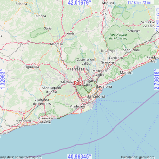
Rubí GPS coordinates[2]
41° 29' 32.136" North, 2° 1' 58.98" East
| Map corner | latitude | longitude |
|---|---|---|
| Upper-left | 42.01679°, | 1.32993° |
| Center: | 41.49226°, | 2.03305° |
| Lower-right: | 40.96345°, | 2.73618° |
| Map W x H: | 117.1×117.1 km | = 72.8×72.8mi |
| max Lat: | 43.74134° ⇑39.3% North |
| Rubí: | 41.49226° |
| min Lat: | ⇓60.7% South 27.64134° |
| min Long | Rubí | max Long |
| -18.00367° | 2.03305° | 4.2899° |
| W 93.6%⇐ | ⇒6.4% E |
Elevation
Elevation of Rubí is 145 m = 476 ft, and this is 453 m = 1486 ft below average elevation for this country.
| Max E: |
1682 m = 5518 ft | 84.7% |
| Avg. | 598 m = 1962 ft | |
| Rubí | 145 m = 476 ft | |
Min E: |
0 m = 0 ft | 15.3% |
See also: Rubí elevation on elevation.city.
Geographical zone
Rubí is located in North temperate zone (between Tropic of Cancer and the Arctic Circle). Distance of this Northern Tropic circle is 2007.6 km =1247.5 mi to South.| Distance of | km | miles | from Rubí |
|---|---|---|---|
| North Pole | 5393.6 | 3351.4 | to North |
| Arctic Circle | 2787.7 | 1732.2 | to North |
| Tropic Cancer | 2007.6 | 1247.5 | to South |
| Equator | 4613.5 | 2866.7 | to South |


Nearby cities:
15 places around Rubí: (largest is in red/bold)
• Barberà del Vallès
8.1 km =5 mi,  70°
70°
• Castellbisbal
4.7 km =2.9 mi,  246°
246°
• Cerdanyola del Vallès
9 km =5.6 mi,  90°
90°
• Martorell
8.8 km =5.5 mi,  256°
256°
• Molins de Rei
8.5 km =5.3 mi,  189°
189°
• Pallejà
8.2 km =5.1 mi,  202°
202°
• Ripollet
10.4 km =6.5 mi, 87°
• Sabadell
8.5 km =5.3 mi,  48°
48°
• Sant Andreu de la Barca
7.2 km =4.5 mi,  225°
225°
• Sant Cugat del Vallès
5 km =3.1 mi,  118°
118°
• Sant Quirze del Vallès
6.2 km =3.9 mi,  42°
42°
• Terrassa
8.4 km =5.2 mi,  350°
350°
• Ullastrell
7.5 km =4.7 mi,  300°
300°
• Vallvidrera, el Tibidabo i les Planes
9.3 km =5.8 mi,  149°
149°
• Viladecavalls
9.4 km =5.8 mi,  312°
312°
Sources, notices
• [Note1] Compared only with cities in Spain existing in our database
• [Src1] Map data: © OpenStreetMap contributors (CC-BY-SA)
• [Src2] Other city data from geonames.org with taken over terms of usage.
• [Src3] Geographical zone / Annual Mean Temperature by Robert A. Rohde @ Wikipedia
