Pallejà geodata
Pallejà (Catalonia) is a seat of a third-order administrative division; located in Spain in Europe/Madrid (GMT+2) time zone. With population of 11,134 people, there are 793 cities with bigger population in this country. Compared to other cities in Spain, 58.7% of cities are located further ↓South; 93.5% of cities are located further ←West and 91.2% of cities have higher elevation than Pallejà. Note1


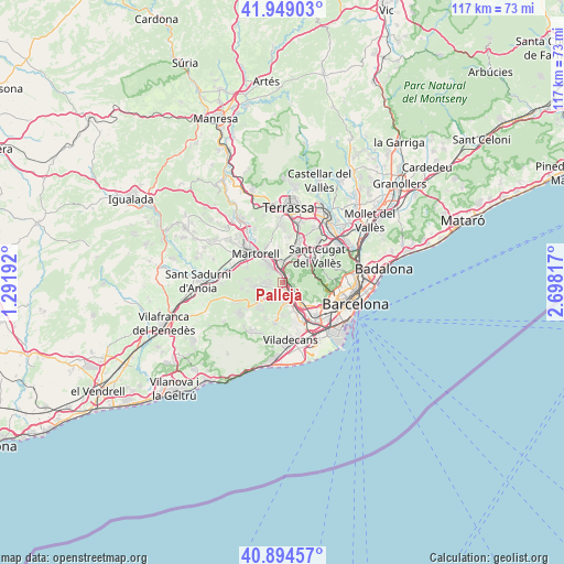
Pallejà GPS coordinates[2]
41° 25' 26.184" North, 1° 59' 42.18" East
| Map corner | latitude | longitude |
|---|---|---|
| Upper-left | 41.94903°, | 1.29192° |
| Center: | 41.42394°, | 1.99505° |
| Lower-right: | 40.89457°, | 2.69817° |
| Map W x H: | 117.2×117.2 km | = 72.8×72.8mi |
| max Lat: | 43.74134° ⇑41.3% North |
| Pallejà: | 41.42394° |
| min Lat: | ⇓58.7% South 27.64134° |
| min Long | Pallejà | max Long |
| -18.00367° | 1.99505° | 4.2899° |
| W 93.5%⇐ | ⇒6.5% E |
Elevation
Elevation of Pallejà is 50 m = 164 ft, and this is 548 m = 1798 ft below average elevation for this country.
| Max E: |
1682 m = 5518 ft | 91.2% |
| Avg. | 598 m = 1962 ft | |
| Pallejà | 50 m = 164 ft | |
Min E: |
0 m = 0 ft | 8.8% |
See also: Spain elevation on elevation.city.
Geographical zone
Pallejà is located in North temperate zone (between Tropic of Cancer and the Arctic Circle). Distance of this Northern Tropic circle is 2000 km =1242.7 mi to South.| Distance of | km | miles | from Pallejà |
|---|---|---|---|
| North Pole | 5401.2 | 3356.1 | to North |
| Arctic Circle | 2795.3 | 1736.9 | to North |
| Tropic Cancer | 2000 | 1242.7 | to South |
| Equator | 4605.9 | 2862 | to South |


Nearby cities:
15 places around Pallejà: (largest is in red/bold)
• Castellbisbal
5.8 km =3.6 mi,  349°
349°
• Cervelló
4.3 km =2.7 mi,  223°
223°
• Corbera de Llobregat
6.3 km =3.9 mi,  263°
263°
• Martorell
7.7 km =4.8 mi,  316°
316°
• Molins de Rei
2 km =1.2 mi,  114°
114°
• Rubí
8.2 km =5.1 mi,  22°
22°
• Sant Andreu de la Barca
3.2 km =2 mi, 322°
• Sant Feliu de Llobregat
6.4 km =4 mi,  134°
134°
• Sant Joan Despí
8.2 km =5.1 mi,  140°
140°
• Sant Just Desvern
7.5 km =4.7 mi, 126°
• Sant Vicenç dels Horts
3.6 km =2.2 mi,  163°
163°
• Santa Coloma de Cervelló
6.5 km =4 mi,  165°
165°
• Torrelles de Llobregat
8.3 km =5.2 mi,  186°
186°
• Vallirana
6.7 km =4.2 mi,  231°
231°
• Vallvidrera, el Tibidabo i les Planes
7.9 km =4.9 mi,  93°
93°
Sources, notices
• [Note1] Compared only with cities in Spain existing in our database
• [Src1] Map data: © OpenStreetMap contributors (CC-BY-SA)
• [Src2] Other city data from geonames.org with taken over terms of usage.
• [Src3] Geographical zone / Annual Mean Temperature by Robert A. Rohde @ Wikipedia
