Rojas geodata
Rojas (Castille and León) is a seat of a third-order administrative division; located in Spain in Europe/Madrid (GMT+2) time zone. With population of 81 people, there are 6123 cities with bigger population in this country. Compared to other cities in Spain, 88.9% of cities are located further ↓South; 51.3% of cities are located further →East and 56.7% of cities have lower elevation than Rojas. Note1


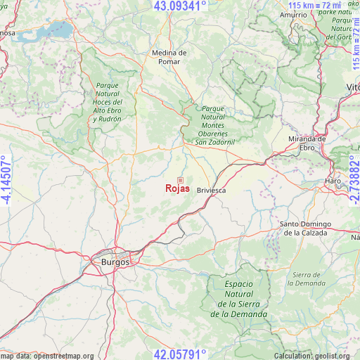
Rojas GPS coordinates[2]
42° 34' 40.116" North, 3° 26' 31.02" West
| Map corner | latitude | longitude |
|---|---|---|
| Upper-left | 43.09341°, | -4.14507° |
| Center: | 42.57781°, | -3.44195° |
| Lower-right: | 42.05791°, | -2.73882° |
| Map W x H: | 115.1×115.1 km | = 71.5×71.5mi |
| max Lat: | 43.74134° ⇑11.1% North |
| Rojas: | 42.57781° |
| min Lat: | ⇓88.9% South 27.64134° |
| min Long | Rojas | max Long |
| -18.00367° | -3.44195° | 4.2899° |
| W 48.7%⇐ | ⇒51.3% E |
Elevation
Elevation of Rojas is 721 m = 2365 ft, and this is 123 m = 404 ft above average elevation for this country.
| Max E: |
1682 m = 5518 ft | 43.3% |
| Rojas | 721 m 2365 ft | |
| Avg. | 598 m = 1962 ft | |
Min E: |
0 m = 0 ft | 56.7% |
See also: Spain elevation on elevation.city.
Geographical zone
Rojas is located in North temperate zone (between Tropic of Cancer and the Arctic Circle). Distance of this Northern Tropic circle is 2128.3 km =1322.5 mi to South.| Distance of | km | miles | from Rojas |
|---|---|---|---|
| North Pole | 5272.9 | 3276.4 | to North |
| Arctic Circle | 2667 | 1657.2 | to North |
| Tropic Cancer | 2128.3 | 1322.5 | to South |
| Equator | 4734.2 | 2941.7 | to South |


Nearby cities:
15 places around Rojas: (largest is in red/bold)
• Aguilar de Bureba
9.3 km =5.8 mi,  81°
81°
• Briviesca
10.2 km =6.3 mi,  107°
107°
• Carcedo de Bureba
4.6 km =2.9 mi,  270°
270°
• Galbarros
5.6 km =3.5 mi,  176°
176°
• Llano de Bureba
5.4 km =3.4 mi,  344°
344°
• Piérnigas
2.7 km =1.7 mi,  59°
59°
• Poza de la Sal
10.9 km =6.8 mi,  333°
333°
• Prádanos de Bureba
11.4 km =7.1 mi,  137°
137°
• Quintanabureba
6.2 km =3.9 mi, 80°
• Quintanavides
10.9 km =6.8 mi,  172°
172°
• Reinoso
9 km =5.6 mi,  148°
148°
• Rublacedo de Abajo
5.6 km =3.5 mi,  241°
241°
• Salinillas de Bureba
5.3 km =3.3 mi,  122°
122°
• Santa Olalla de Bureba
11.2 km =7 mi, 179°
• Vileña
10.9 km =6.8 mi, 63°
Sources, notices
• [Note1] Compared only with cities in Spain existing in our database
• [Src1] Map data: © OpenStreetMap contributors (CC-BY-SA)
• [Src2] Other city data from geonames.org with taken over terms of usage.
• [Src3] Geographical zone / Annual Mean Temperature by Robert A. Rohde @ Wikipedia
