Vileña geodata
Vileña (Castille and León) is a seat of a third-order administrative division; located in Spain in Europe/Madrid (GMT+2) time zone. With population of 29 people, there are 6669 cities with bigger population in this country. Compared to other cities in Spain, 90% of cities are located further ↓South; 50.2% of cities are located further ←West and 50.8% of cities have lower elevation than Vileña. Note1


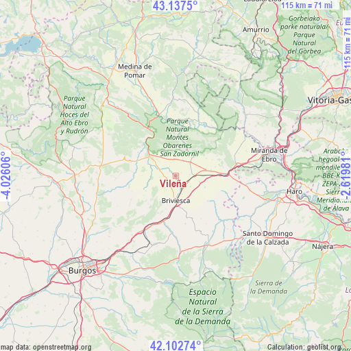
Vileña GPS coordinates[2]
42° 37' 20.172" North, 3° 19' 22.548" West
| Map corner | latitude | longitude |
|---|---|---|
| Upper-left | 43.1375°, | -4.02606° |
| Center: | 42.62227°, | -3.32293° |
| Lower-right: | 42.10274°, | -2.61981° |
| Map W x H: | 115.1×115.1 km | = 71.5×71.5mi |
| max Lat: | 43.74134° ⇑10% North |
| Vileña: | 42.62227° |
| min Lat: | ⇓90% South 27.64134° |
| min Long | Vileña | max Long |
| -18.00367° | -3.32293° | 4.2899° |
| W 50.2%⇐ | ⇒49.8% E |
Elevation
Elevation of Vileña is 667 m = 2188 ft, and this is 69 m = 226 ft above average elevation for this country.
| Max E: |
1682 m = 5518 ft | 49.2% |
| Vileña | 667 m 2188 ft | |
| Avg. | 598 m = 1962 ft | |
Min E: |
0 m = 0 ft | 50.8% |
See also: Spain elevation on elevation.city.
Geographical zone
Vileña is located in North temperate zone (between Tropic of Cancer and the Arctic Circle). Distance of this Northern Tropic circle is 2133.2 km =1325.5 mi to South.| Distance of | km | miles | from Vileña |
|---|---|---|---|
| North Pole | 5267.9 | 3273.3 | to North |
| Arctic Circle | 2662 | 1654.1 | to North |
| Tropic Cancer | 2133.2 | 1325.5 | to South |
| Equator | 4739.2 | 2944.8 | to South |


Nearby cities:
15 places around Vileña: (largest is in red/bold)
• Aguilar de Bureba
3.7 km =2.3 mi,  187°
187°
• Berzosa de Bureba
4.6 km =2.9 mi,  83°
83°
• Briviesca
8 km =5 mi,  180°
180°
• Busto de Bureba
6.3 km =3.9 mi,  49°
49°
• Cascajares de Bureba
9.4 km =5.8 mi, 47°
• Cubo de Bureba
9.7 km =6 mi, 78°
• Fuentebureba
7.3 km =4.5 mi, 79°
• Grisaleña
5.9 km =3.7 mi,  125°
125°
• Navas de Bureba
6.5 km =4 mi,  357°
357°
• Piérnigas
8.2 km =5.1 mi,  244°
244°
• Quintanabureba
5.3 km =3.3 mi,  222°
222°
• Quintanaélez
5.6 km =3.5 mi,  20°
20°
• Salinillas de Bureba
9.4 km =5.8 mi,  214°
214°
• Vallarta de Bureba
10.4 km =6.5 mi,  111°
111°
• Zuñeda
8.1 km =5 mi,  103°
103°
Sources, notices
• [Note1] Compared only with cities in Spain existing in our database
• [Src1] Map data: © OpenStreetMap contributors (CC-BY-SA)
• [Src2] Other city data from geonames.org with taken over terms of usage.
• [Src3] Geographical zone / Annual Mean Temperature by Robert A. Rohde @ Wikipedia
