Riós geodata
Riós (Galicia) is a seat of a third-order administrative division; located in Spain in Europe/Madrid (GMT+2) time zone. With population of 2,074 people, there are 2115 cities with bigger population in this country. Compared to other cities in Spain, 73% of cities are located further ↓South; 95% of cities are located further →East and 68.9% of cities have lower elevation than Riós. Note1


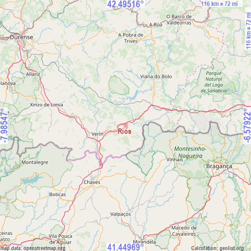
Riós GPS coordinates[2]
41° 58' 28.452" North, 7° 16' 56.424" West
| Map corner | latitude | longitude |
|---|---|---|
| Upper-left | 42.49516°, | -7.98547° |
| Center: | 41.97457°, | -7.28234° |
| Lower-right: | 41.44969°, | -6.57922° |
| Map W x H: | 116.2×116.2 km | = 72.2×72.2mi |
| max Lat: | 43.74134° ⇑27% North |
| Riós: | 41.97457° |
| min Lat: | ⇓73% South 27.64134° |
| min Long | Riós | max Long |
| -18.00367° | -7.28234° | 4.2899° |
| W 5%⇐ | ⇒95% E |
Elevation
Elevation of Riós is 805 m = 2641 ft, and this is 207 m = 679 ft above average elevation for this country.
| Max E: |
1682 m = 5518 ft | 31.1% |
| Riós | 805 m 2641 ft | |
| Avg. | 598 m = 1962 ft | |
Min E: |
0 m = 0 ft | 68.9% |
See also: Spain elevation on elevation.city.
Geographical zone
Riós is located in North temperate zone (between Tropic of Cancer and the Arctic Circle). Distance of this Northern Tropic circle is 2061.2 km =1280.8 mi to South.| Distance of | km | miles | from Riós |
|---|---|---|---|
| North Pole | 5339.9 | 3318.1 | to North |
| Arctic Circle | 2734 | 1698.8 | to North |
| Tropic Cancer | 2061.2 | 1280.8 | to South |
| Equator | 4667.1 | 2900 | to South |


Nearby cities:
15 places around Riós: (largest is in red/bold)
• Baltar
35.9 km =22.3 mi,  265°
265°
• Cualedro
25.9 km =16.1 mi, 273°
• Hermisende
31.9 km =19.8 mi,  91°
91°
• Laza
17.7 km =11 mi,  303°
303°
• Lubián
31.9 km =19.8 mi,  77°
77°
• Manzaneda
37.5 km =23.3 mi,  6°
6°
• Montederramo
38 km =23.6 mi,  331°
331°
• Oimbra
18.6 km =11.6 mi,  237°
237°
• Porto
38.2 km =23.7 mi,  55°
55°
• Pías
26.3 km =16.3 mi, 62°
• Sarreaus
29.4 km =18.3 mi, 295°
• Trasmiras
28.3 km =17.6 mi,  281°
281°
• Verín
13.4 km =8.3 mi,  254°
254°
• Vilariño de Conso
22.9 km =14.2 mi,  20°
20°
• Xinzo de Limia
37.8 km =23.5 mi,  285°
285°
Sources, notices
• [Note1] Compared only with cities in Spain existing in our database
• [Src1] Map data: © OpenStreetMap contributors (CC-BY-SA)
• [Src2] Other city data from geonames.org with taken over terms of usage.
• [Src3] Geographical zone / Annual Mean Temperature by Robert A. Rohde @ Wikipedia
