Montederramo geodata
Montederramo (Galicia) is a seat of a third-order administrative division; located in Spain in Europe/Madrid (GMT+2) time zone. With population of 1,085 people, there are 2838 cities with bigger population in this country. Compared to other cities in Spain, 81.3% of cities are located further ↓South; 95.4% of cities are located further →East and 80.9% of cities have lower elevation than Montederramo. Note1


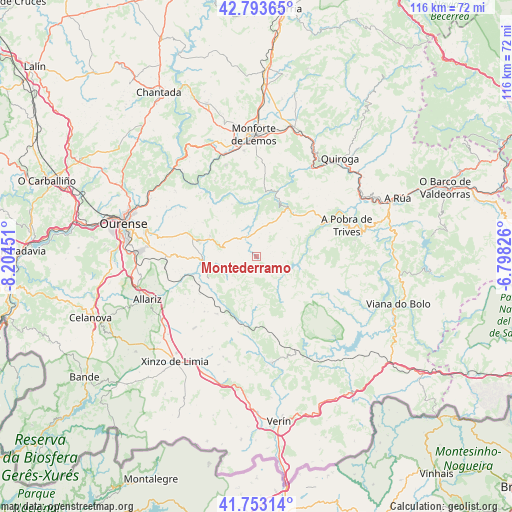
Montederramo GPS coordinates[2]
42° 16' 31.944" North, 7° 30' 4.968" West
| Map corner | latitude | longitude |
|---|---|---|
| Upper-left | 42.79365°, | -8.20451° |
| Center: | 42.27554°, | -7.50138° |
| Lower-right: | 41.75314°, | -6.79826° |
| Map W x H: | 115.7×115.7 km | = 71.9×71.9mi |
| max Lat: | 43.74134° ⇑18.7% North |
| Montederramo: | 42.27554° |
| min Lat: | ⇓81.3% South 27.64134° |
| min Long | Montederramo | max Long |
| -18.00367° | -7.50138° | 4.2899° |
| W 4.6%⇐ | ⇒95.4% E |
Elevation
Elevation of Montederramo is 906 m = 2972 ft, and this is 308 m = 1010 ft above average elevation for this country.
| Max E: |
1682 m = 5518 ft | 19.1% |
| Montederramo | 906 m 2972 ft | |
| Avg. | 598 m = 1962 ft | |
Min E: |
0 m = 0 ft | 80.9% |
See also: Spain elevation on elevation.city.
Geographical zone
Montederramo is located in North temperate zone (between Tropic of Cancer and the Arctic Circle). Distance of this Northern Tropic circle is 2094.7 km =1301.6 mi to South.| Distance of | km | miles | from Montederramo |
|---|---|---|---|
| North Pole | 5306.5 | 3297.3 | to North |
| Arctic Circle | 2700.6 | 1678.1 | to North |
| Tropic Cancer | 2094.7 | 1301.6 | to South |
| Equator | 4700.6 | 2920.8 | to South |


Nearby cities:
15 places around Montederramo: (largest is in red/bold)
• Allariz
26.5 km =16.5 mi,  249°
249°
• Ambía
20.9 km =13 mi, 248°
• Baños de Molgas
14.6 km =9.1 mi, 254°
• Castro Caldelas
12.6 km =7.8 mi,  29°
29°
• Esgos
17 km =10.6 mi,  289°
289°
• Laza
24 km =14.9 mi,  172°
172°
• Lobios
14.9 km =9.3 mi,  350°
350°
• Luintra
23.8 km =14.8 mi,  308°
308°
• Maceda
12.3 km =7.6 mi,  266°
266°
• Manzaneda
22.5 km =14 mi,  80°
80°
• Nogueira de Ramuín
25.8 km =16 mi, 307°
• Pereiro de Aguiar
25.8 km =16 mi, 287°
• Pobra de Trives
21.6 km =13.4 mi,  70°
70°
• Sarreaus
22.5 km =14 mi,  201°
201°
• Sober
21.8 km =13.5 mi,  341°
341°
Sources, notices
• [Note1] Compared only with cities in Spain existing in our database
• [Src1] Map data: © OpenStreetMap contributors (CC-BY-SA)
• [Src2] Other city data from geonames.org with taken over terms of usage.
• [Src3] Geographical zone / Annual Mean Temperature by Robert A. Rohde @ Wikipedia
