Ribaforada geodata
Ribaforada (Navarre) is a seat of a third-order administrative division; located in Spain in Europe/Madrid (GMT+2) time zone. With population of 3,412 people, there are 1606 cities with bigger population in this country. Compared to other cities in Spain, 73.8% of cities are located further ↓South; 72.7% of cities are located further ←West and 77.6% of cities have higher elevation than Ribaforada. Note1


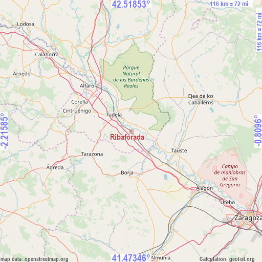
Ribaforada GPS coordinates[2]
41° 59' 53.304" North, 1° 30' 45.792" West
| Map corner | latitude | longitude |
|---|---|---|
| Upper-left | 42.51853°, | -2.21585° |
| Center: | 41.99814°, | -1.51272° |
| Lower-right: | 41.47346°, | -0.8096° |
| Map W x H: | 116.2×116.2 km | = 72.2×72.2mi |
| max Lat: | 43.74134° ⇑26.2% North |
| Ribaforada: | 41.99814° |
| min Lat: | ⇓73.8% South 27.64134° |
| min Long | Ribaforada | max Long |
| -18.00367° | -1.51272° | 4.2899° |
| W 72.7%⇐ | ⇒27.3% E |
Elevation
Elevation of Ribaforada is 262 m = 860 ft, and this is 336 m = 1102 ft below average elevation for this country.
| Max E: |
1682 m = 5518 ft | 77.6% |
| Avg. | 598 m = 1962 ft | |
| Ribaforada | 262 m = 860 ft | |
Min E: |
0 m = 0 ft | 22.4% |
See also: Spain elevation on elevation.city.
Geographical zone
Ribaforada is located in North temperate zone (between Tropic of Cancer and the Arctic Circle). Distance of this Northern Tropic circle is 2063.8 km =1282.4 mi to South.| Distance of | km | miles | from Ribaforada |
|---|---|---|---|
| North Pole | 5337.3 | 3316.4 | to North |
| Arctic Circle | 2731.4 | 1697.2 | to North |
| Tropic Cancer | 2063.8 | 1282.4 | to South |
| Equator | 4669.8 | 2901.7 | to South |


Nearby cities:
15 places around Ribaforada: (largest is in red/bold)
• Ablitas
10.9 km =6.8 mi,  256°
256°
• Barillas
10.6 km =6.6 mi,  250°
250°
• Buñuel
5.9 km =3.7 mi,  109°
109°
• Cabanillas
4 km =2.5 mi,  344°
344°
• Cascante
13.9 km =8.6 mi,  269°
269°
• Cortes
11.3 km =7 mi,  137°
137°
• Fontellas
6.2 km =3.9 mi,  301°
301°
• Fréscano
13.8 km =8.6 mi,  157°
157°
• Fustiñana
3.4 km =2.1 mi,  41°
41°
• Mallén
13.3 km =8.3 mi, 144°
• Malón
14.1 km =8.8 mi, 248°
• Murchante
12.4 km =7.7 mi,  287°
287°
• Novillas
12.2 km =7.6 mi,  126°
126°
• Tudela
10.4 km =6.5 mi,  312°
312°
• Tulebras
13.7 km =8.5 mi, 260°
Sources, notices
• [Note1] Compared only with cities in Spain existing in our database
• [Src1] Map data: © OpenStreetMap contributors (CC-BY-SA)
• [Src2] Other city data from geonames.org with taken over terms of usage.
• [Src3] Geographical zone / Annual Mean Temperature by Robert A. Rohde @ Wikipedia
