Fustiñana geodata
Fustiñana (Navarre) is a seat of a third-order administrative division; located in Spain in Europe/Madrid (GMT+2) time zone. With population of 2,550 people, there are 1883 cities with bigger population in this country. Compared to other cities in Spain, 74.3% of cities are located further ↓South; 73.1% of cities are located further ←West and 77.6% of cities have higher elevation than Fustiñana. Note1


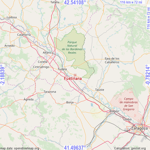
Fustiñana GPS coordinates[2]
42° 1' 15.132" North, 1° 29' 6.936" West
| Map corner | latitude | longitude |
|---|---|---|
| Upper-left | 42.54108°, | -2.18839° |
| Center: | 42.02087°, | -1.48526° |
| Lower-right: | 41.49637°, | -0.78214° |
| Map W x H: | 116.2×116.2 km | = 72.2×72.2mi |
| max Lat: | 43.74134° ⇑25.7% North |
| Fustiñana: | 42.02087° |
| min Lat: | ⇓74.3% South 27.64134° |
| min Long | Fustiñana | max Long |
| -18.00367° | -1.48526° | 4.2899° |
| W 73.1%⇐ | ⇒26.9% E |
Elevation
Elevation of Fustiñana is 262 m = 860 ft, and this is 336 m = 1102 ft below average elevation for this country.
| Max E: |
1682 m = 5518 ft | 77.6% |
| Avg. | 598 m = 1962 ft | |
| Fustiñana | 262 m = 860 ft | |
Min E: |
0 m = 0 ft | 22.4% |
See also: Spain elevation on elevation.city.
Geographical zone
Fustiñana is located in North temperate zone (between Tropic of Cancer and the Arctic Circle). Distance of this Northern Tropic circle is 2066.4 km =1284 mi to South.| Distance of | km | miles | from Fustiñana |
|---|---|---|---|
| North Pole | 5334.8 | 3314.9 | to North |
| Arctic Circle | 2728.9 | 1695.7 | to North |
| Tropic Cancer | 2066.4 | 1284 | to South |
| Equator | 4672.3 | 2903.2 | to South |


Nearby cities:
15 places around Fustiñana: (largest is in red/bold)
• Ablitas
13.8 km =8.6 mi,  248°
248°
• Barillas
13.6 km =8.5 mi,  243°
243°
• Buñuel
5.6 km =3.5 mi,  143°
143°
• Cabanillas
3.6 km =2.2 mi,  291°
291°
• Cascante
16.4 km =10.2 mi,  260°
260°
• Cortes
12.2 km =7.6 mi,  153°
153°
• Fontellas
7.6 km =4.7 mi,  275°
275°
• Fréscano
15.6 km =9.7 mi,  169°
169°
• Mallén
14.4 km =8.9 mi,  158°
158°
• Malón
17.2 km =10.7 mi, 243°
• Murchante
14.1 km =8.8 mi,  274°
274°
• Novillas
12.3 km =7.6 mi, 142°
• Ribaforada
3.4 km =2.1 mi,  221°
221°
• Tudela
10.8 km =6.7 mi, 294°
• Tulebras
16.5 km =10.3 mi, 252°
Sources, notices
• [Note1] Compared only with cities in Spain existing in our database
• [Src1] Map data: © OpenStreetMap contributors (CC-BY-SA)
• [Src2] Other city data from geonames.org with taken over terms of usage.
• [Src3] Geographical zone / Annual Mean Temperature by Robert A. Rohde @ Wikipedia
