Barillas geodata
Barillas (Navarre) is a seat of a third-order administrative division; located in Spain in Europe/Madrid (GMT+2) time zone. With population of 212 people, there are 4965 cities with bigger population in this country. Compared to other cities in Spain, 72.7% of cities are located further ↓South; 71.6% of cities are located further ←West and 68.4% of cities have higher elevation than Barillas. Note1


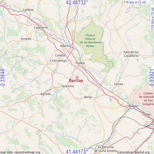
Barillas GPS coordinates[2]
41° 58' 0.012" North, 1° 37' 59.988" West
| Map corner | latitude | longitude |
|---|---|---|
| Upper-left | 42.48732°, | -2.33646° |
| Center: | 41.96667°, | -1.63333° |
| Lower-right: | 41.44173°, | -0.93021° |
| Map W x H: | 116.3×116.3 km | = 72.3×72.3mi |
| max Lat: | 43.74134° ⇑27.3% North |
| Barillas: | 41.96667° |
| min Lat: | ⇓72.7% South 27.64134° |
| min Long | Barillas | max Long |
| -18.00367° | -1.63333° | 4.2899° |
| W 71.6%⇐ | ⇒28.4% E |
Elevation
Elevation of Barillas is 409 m = 1342 ft, and this is 189 m = 620 ft below average elevation for this country.
| Max E: |
1682 m = 5518 ft | 68.4% |
| Avg. | 598 m = 1962 ft | |
| Barillas | 409 m = 1342 ft | |
Min E: |
0 m = 0 ft | 31.6% |
See also: Spain elevation on elevation.city.
Geographical zone
Barillas is located in North temperate zone (between Tropic of Cancer and the Arctic Circle). Distance of this Northern Tropic circle is 2060.3 km =1280.2 mi to South.| Distance of | km | miles | from Barillas |
|---|---|---|---|
| North Pole | 5340.8 | 3318.6 | to North |
| Arctic Circle | 2734.9 | 1699.4 | to North |
| Tropic Cancer | 2060.3 | 1280.2 | to South |
| Equator | 4666.3 | 2899.5 | to South |


Nearby cities:
15 places around Barillas: (largest is in red/bold)
• Ablitas
1.1 km =0.7 mi,  325°
325°
• Cabanillas
11.5 km =7.1 mi,  50°
50°
• Cascante
5.2 km =3.2 mi,  311°
311°
• Fontellas
8.2 km =5.1 mi,  35°
35°
• Fustiñana
13.6 km =8.5 mi,  63°
63°
• Grisel
13.2 km =8.2 mi,  216°
216°
• Malón
3.6 km =2.2 mi,  243°
243°
• Monteagudo
4.1 km =2.5 mi,  270°
270°
• Murchante
7.5 km =4.7 mi,  345°
345°
• Novallas
5.8 km =3.6 mi,  251°
251°
• Ribaforada
10.6 km =6.6 mi,  70°
70°
• Tarazona
10.4 km =6.5 mi,  228°
228°
• Tudela
10.8 km =6.7 mi,  12°
12°
• Tulebras
3.7 km =2.3 mi,  287°
287°
• Vierlas
5.9 km =3.7 mi, 221°
Sources, notices
• [Note1] Compared only with cities in Spain existing in our database
• [Src1] Map data: © OpenStreetMap contributors (CC-BY-SA)
• [Src2] Other city data from geonames.org with taken over terms of usage.
• [Src3] Geographical zone / Annual Mean Temperature by Robert A. Rohde @ Wikipedia
