Tulebras geodata
Tulebras (Navarre) is a seat of a third-order administrative division; located in Spain in Europe/Madrid (GMT+2) time zone. With population of 106 people, there are 5853 cities with bigger population in this country. Compared to other cities in Spain, 73.1% of cities are located further ↓South; 71% of cities are located further ←West and 70.4% of cities have higher elevation than Tulebras. Note1


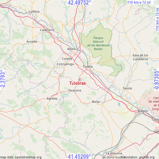
Tulebras GPS coordinates[2]
41° 58' 37.02" North, 1° 40' 34.248" West
| Map corner | latitude | longitude |
|---|---|---|
| Upper-left | 42.49752°, | -2.3793° |
| Center: | 41.97695°, | -1.67618° |
| Lower-right: | 41.45209°, | -0.97305° |
| Map W x H: | 116.2×116.2 km | = 72.2×72.2mi |
| max Lat: | 43.74134° ⇑26.9% North |
| Tulebras: | 41.97695° |
| min Lat: | ⇓73.1% South 27.64134° |
| min Long | Tulebras | max Long |
| -18.00367° | -1.67618° | 4.2899° |
| W 71%⇐ | ⇒29% E |
Elevation
Elevation of Tulebras is 375 m = 1230 ft, and this is 223 m = 732 ft below average elevation for this country.
| Max E: |
1682 m = 5518 ft | 70.4% |
| Avg. | 598 m = 1962 ft | |
| Tulebras | 375 m = 1230 ft | |
Min E: |
0 m = 0 ft | 29.6% |
See also: Spain elevation on elevation.city.
Geographical zone
Tulebras is located in North temperate zone (between Tropic of Cancer and the Arctic Circle). Distance of this Northern Tropic circle is 2061.5 km =1281 mi to South.| Distance of | km | miles | from Tulebras |
|---|---|---|---|
| North Pole | 5339.7 | 3317.9 | to North |
| Arctic Circle | 2733.8 | 1698.7 | to North |
| Tropic Cancer | 2061.5 | 1281 | to South |
| Equator | 4667.4 | 2900.2 | to South |


Nearby cities:
15 places around Tulebras: (largest is in red/bold)
• Ablitas
3 km =1.9 mi,  95°
95°
• Barillas
3.7 km =2.3 mi,  107°
107°
• Cascante
2.3 km =1.4 mi,  350°
350°
• Fontellas
9.9 km =6.2 mi,  55°
55°
• Grisel
12.5 km =7.8 mi,  199°
199°
• Malón
2.8 km =1.7 mi,  172°
172°
• Monteagudo
1.3 km =0.8 mi,  207°
207°
• Murchante
6.3 km =3.9 mi,  15°
15°
• Novallas
3.6 km =2.2 mi, 213°
• Ribaforada
13.7 km =8.5 mi,  80°
80°
• Santa Cruz de Moncayo
12.4 km =7.7 mi, 212°
• Tarazona
9.1 km =5.7 mi, 207°
• Torrellas
12.1 km =7.5 mi,  220°
220°
• Tudela
11.1 km =6.9 mi,  32°
32°
• Vierlas
5.6 km =3.5 mi,  184°
184°
Sources, notices
• [Note1] Compared only with cities in Spain existing in our database
• [Src1] Map data: © OpenStreetMap contributors (CC-BY-SA)
• [Src2] Other city data from geonames.org with taken over terms of usage.
• [Src3] Geographical zone / Annual Mean Temperature by Robert A. Rohde @ Wikipedia
