Rello geodata
Rello (Castille and León) is a seat of a third-order administrative division; located in Spain in Europe/Madrid (GMT+2) time zone. With population of 32 people, there are 6640 cities with bigger population in this country. Compared to other cities in Spain, 55.9% of cities are located further ↓South; 58.1% of cities are located further ←West and 92.3% of cities have lower elevation than Rello. Note1


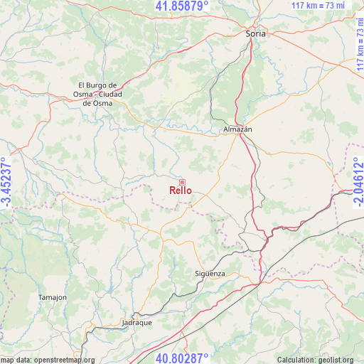
Rello GPS coordinates[2]
41° 19' 58.692" North, 2° 44' 57.3" West
| Map corner | latitude | longitude |
|---|---|---|
| Upper-left | 41.85879°, | -3.45237° |
| Center: | 41.33297°, | -2.74925° |
| Lower-right: | 40.80287°, | -2.04612° |
| Map W x H: | 117.4×117.4 km | = 72.9×72.9mi |
| max Lat: | 43.74134° ⇑44.1% North |
| Rello: | 41.33297° |
| min Lat: | ⇓55.9% South 27.64134° |
| min Long | Rello | max Long |
| -18.00367° | -2.74925° | 4.2899° |
| W 58.1%⇐ | ⇒41.9% E |
Elevation
Elevation of Rello is 1076 m = 3530 ft, and this is 478 m = 1568 ft above average elevation for this country.
| Max E: |
1682 m = 5518 ft | 7.7% |
| Rello | 1076 m 3530 ft | |
| Avg. | 598 m = 1962 ft | |
Min E: |
0 m = 0 ft | 92.3% |
See also: Spain elevation on elevation.city.
Geographical zone
Rello is located in North temperate zone (between Tropic of Cancer and the Arctic Circle). Distance of this Northern Tropic circle is 1989.9 km =1236.5 mi to South.| Distance of | km | miles | from Rello |
|---|---|---|---|
| North Pole | 5411.3 | 3362.4 | to North |
| Arctic Circle | 2805.4 | 1743.2 | to North |
| Tropic Cancer | 1989.9 | 1236.5 | to South |
| Equator | 4595.8 | 2855.7 | to South |


Nearby cities:
15 places around Rello: (largest is in red/bold)
• Alcolea de las Peñas
14 km =8.7 mi,  192°
192°
• Alpanseque
10 km =6.2 mi,  138°
138°
• Arenillas
8.2 km =5.1 mi,  280°
280°
• Barca
17.2 km =10.7 mi,  38°
38°
• Barcones
7.3 km =4.5 mi,  230°
230°
• Bañuelos
14.8 km =9.2 mi,  249°
249°
• Caltojar
7.8 km =4.8 mi,  350°
350°
• Cincovillas
15.4 km =9.6 mi,  202°
202°
• Paredes de Sigüenza
10.1 km =6.3 mi,  172°
172°
• Romanillos de Atienza
14.6 km =9.1 mi,  239°
239°
• Sienes
16.7 km =10.4 mi,  151°
151°
• Tordelrábano
12.8 km =8 mi,  183°
183°
• Valdelcubo
13.3 km =8.3 mi, 152°
• Velamazán
13.6 km =8.5 mi,  17°
17°
• Villasayas
11.8 km =7.3 mi,  79°
79°
Sources, notices
• [Note1] Compared only with cities in Spain existing in our database
• [Src1] Map data: © OpenStreetMap contributors (CC-BY-SA)
• [Src2] Other city data from geonames.org with taken over terms of usage.
• [Src3] Geographical zone / Annual Mean Temperature by Robert A. Rohde @ Wikipedia
