Regencós geodata
Regencós (Catalonia) is a seat of a third-order administrative division; located in Spain in Europe/Madrid (GMT+2) time zone. With population of 316 people, there are 4434 cities with bigger population in this country. Compared to other cities in Spain, 72.4% of cities are located further ↓South; 99.7% of cities are located further ←West and 89.2% of cities have higher elevation than Regencós. Note1


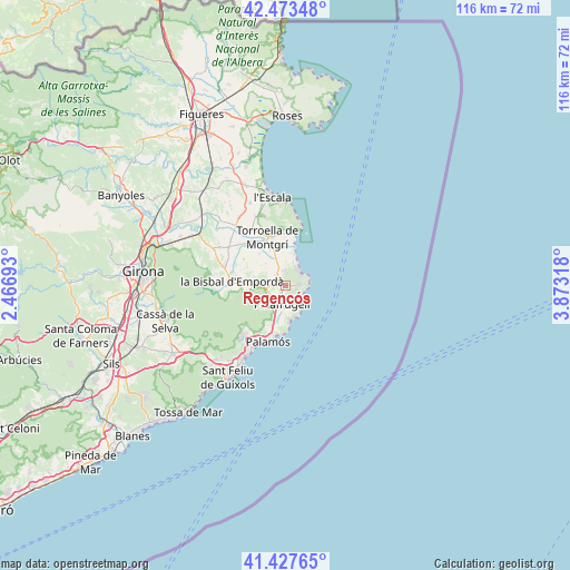
Regencós GPS coordinates[2]
41° 57' 9.756" North, 3° 10' 12.216" East
| Map corner | latitude | longitude |
|---|---|---|
| Upper-left | 42.47348°, | 2.46693° |
| Center: | 41.95271°, | 3.17006° |
| Lower-right: | 41.42765°, | 3.87318° |
| Map W x H: | 116.3×116.3 km | = 72.3×72.3mi |
| max Lat: | 43.74134° ⇑27.6% North |
| Regencós: | 41.95271° |
| min Lat: | ⇓72.4% South 27.64134° |
| min Long | Regencós | max Long |
| -18.00367° | 3.17006° | 4.2899° |
| W 99.7%⇐ | ⇒0.3% E |
Elevation
Elevation of Regencós is 77 m = 253 ft, and this is 521 m = 1709 ft below average elevation for this country.
| Max E: |
1682 m = 5518 ft | 89.2% |
| Avg. | 598 m = 1962 ft | |
| Regencós | 77 m = 253 ft | |
Min E: |
0 m = 0 ft | 10.8% |
See also: Spain elevation on elevation.city.
Geographical zone
Regencós is located in North temperate zone (between Tropic of Cancer and the Arctic Circle). Distance of this Northern Tropic circle is 2058.8 km =1279.3 mi to South.| Distance of | km | miles | from Regencós |
|---|---|---|---|
| North Pole | 5342.4 | 3319.6 | to North |
| Arctic Circle | 2736.5 | 1700.4 | to North |
| Tropic Cancer | 2058.8 | 1279.3 | to South |
| Equator | 4664.7 | 2898.5 | to South |


Nearby cities:
15 places around Regencós: (largest is in red/bold)
• Begur
3.9 km =2.4 mi,  94°
94°
• Calella de Palafrugell
6.9 km =4.3 mi,  168°
168°
• Fontanilles
8.3 km =5.2 mi,  321°
321°
• Gualta
10.2 km =6.3 mi,  327°
327°
• Palafrugell
4 km =2.5 mi,  188°
188°
• Palau-sator
6.4 km =4 mi,  309°
309°
• Pals
2.7 km =1.7 mi, 318°
• Serra de Daró
11.7 km =7.3 mi, 316°
• Torrent
3.6 km =2.2 mi,  269°
269°
• Torroella de Montgrí
10.6 km =6.6 mi,  340°
340°
• Ullastret
10 km =6.2 mi,  301°
301°
• Ullà
12 km =7.5 mi, 334°
• Vall-Llobrega
8.8 km =5.5 mi,  204°
204°
• l'Estartit
11.4 km =7.1 mi,  11°
11°
• la Bisbal d'Empordà
9.9 km =6.2 mi, 268°
Sources, notices
• [Note1] Compared only with cities in Spain existing in our database
• [Src1] Map data: © OpenStreetMap contributors (CC-BY-SA)
• [Src2] Other city data from geonames.org with taken over terms of usage.
• [Src3] Geographical zone / Annual Mean Temperature by Robert A. Rohde @ Wikipedia
