Calella de Palafrugell geodata
Calella de Palafrugell (Catalonia) is a populated place; located in Spain in Europe/Madrid (GMT+2) time zone. With population of 747 people, there are 3309 cities with bigger population in this country. Compared to other cities in Spain, 70.7% of cities are located further ↓South; 99.7% of cities are located further ←West and 94.3% of cities have higher elevation than Calella de Palafrugell. Note1
Current local time in Calella de Palafrugell:
11:55 PM, ThursdayDifference from your time zone: hours


Calella de Palafrugell GPS coordinates[2]
41° 53' 31.164" North, 3° 11' 11.724" East
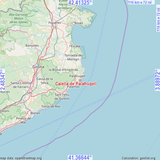
| Map corner | latitude | longitude |
|---|---|---|
| Upper-left | 42.41325°, | 2.48347° |
| Center: | 41.89199°, | 3.18659° |
| Lower-right: | 41.36644°, | 3.88972° |
| Map W x H: | 116.4×116.4 km | = 72.3×72.3mi |
| max Lat: | 43.74134° ⇑29.3% North |
| Calella de Palafrugell: | 41.89199° |
| min Lat: | ⇓70.7% South 27.64134° |
| min Long | Calella de Pala | max Long |
| -18.00367° | 3.18659° | 4.2899° |
| W 99.7%⇐ | ⇒0.3% E |
Elevation
Elevation of Calella de Palafrugell is 29 m = 95 ft, and this is 569 m = 1867 ft below average elevation for this country.
| Max E: |
1682 m = 5518 ft | 94.3% |
| Avg. | 598 m = 1962 ft | |
| Calella de Palafrugell | 29 m = 95 ft | |
Min E: |
0 m = 0 ft | 5.7% |
See also: Spain elevation on elevation.city.
Geographical zone
Calella de Palafrugell is located in North temperate zone (between Tropic of Cancer and the Arctic Circle). Distance of this Northern Tropic circle is 2052 km =1275.1 mi to South.| Distance of | km | miles | from Calella de Palafrugell |
|---|---|---|---|
| North Pole | 5349.1 | 3323.8 | to North |
| Arctic Circle | 2743.2 | 1704.5 | to North |
| Tropic Cancer | 2052 | 1275.1 | to South |
| Equator | 4658 | 2894.3 | to South |


Nearby cities:
15 places around Calella de Palafrugell: (largest is in red/bold)
• Begur
6.9 km =4.3 mi,  21°
21°
• Calonge
9.6 km =6 mi,  247°
247°
• Castell-Platja d'Aro
12.9 km =8 mi,  230°
230°
• Cruïlles
15.5 km =9.6 mi,  294°
294°
• Fontanilles
14.8 km =9.2 mi,  333°
333°
• Palafrugell
3.4 km =2.1 mi, 325°
• Palamós
6.8 km =4.2 mi,  224°
224°
• Palau-sator
12.5 km =7.8 mi, 329°
• Pals
9.3 km =5.8 mi,  340°
340°
• Regencós
6.9 km =4.3 mi,  348°
348°
• S'Agaró
15.5 km =9.6 mi, 225°
• Torrent
8.3 km =5.2 mi,  323°
323°
• Ullastret
15.6 km =9.7 mi, 320°
• Vall-Llobrega
5.1 km =3.2 mi,  255°
255°
• la Bisbal d'Empordà
13 km =8.1 mi,  299°
299°
Sources, notices
• [Note1] Compared only with cities in Spain existing in our database
• [Src1] Map data: © OpenStreetMap contributors (CC-BY-SA)
• [Src2] Other city data from geonames.org with taken over terms of usage.
• [Src3] Geographical zone / Annual Mean Temperature by Robert A. Rohde @ Wikipedia
