Garcia geodata
Garcia (Catalonia) is a seat of a third-order administrative division; located in Spain in Europe/Madrid (GMT+2) time zone. With population of 496 people, there are 3901 cities with bigger population in this country. Compared to other cities in Spain, 51.7% of cities are located further ↓South; 89.5% of cities are located further ←West and 94.4% of cities have higher elevation than Garcia. Note1


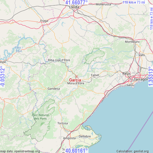
Garcia GPS coordinates[2]
41° 7' 59.988" North, 0° 39' 0" East
| Map corner | latitude | longitude |
|---|---|---|
| Upper-left | 41.66077°, | -0.05312° |
| Center: | 41.13333°, | 0.65° |
| Lower-right: | 40.60161°, | 1.35313° |
| Map W x H: | 117.8×117.8 km | = 73.2×73.2mi |
| max Lat: | 43.74134° ⇑48.3% North |
| Garcia: | 41.13333° |
| min Lat: | ⇓51.7% South 27.64134° |
| min Long | Garcia | max Long |
| -18.00367° | 0.65° | 4.2899° |
| W 89.5%⇐ | ⇒10.5% E |
Elevation
Elevation of Garcia is 28 m = 92 ft, and this is 570 m = 1870 ft below average elevation for this country.
| Max E: |
1682 m = 5518 ft | 94.4% |
| Avg. | 598 m = 1962 ft | |
| Garcia | 28 m = 92 ft | |
Min E: |
0 m = 0 ft | 5.6% |
See also: Spain elevation on elevation.city.
Geographical zone
Garcia is located in North temperate zone (between Tropic of Cancer and the Arctic Circle). Distance of this Northern Tropic circle is 1967.7 km =1222.7 mi to South.| Distance of | km | miles | from Garcia |
|---|---|---|---|
| North Pole | 5433.5 | 3376.2 | to North |
| Arctic Circle | 2827.6 | 1757 | to North |
| Tropic Cancer | 1967.7 | 1222.7 | to South |
| Equator | 4573.6 | 2841.9 | to South |


Nearby cities:
15 places around Garcia: (largest is in red/bold)
• Ascó
8.9 km =5.5 mi,  308°
308°
• Colldejou
20.2 km =12.6 mi,  100°
100°
• Falset
14.3 km =8.9 mi,  84°
84°
• Flix
13.7 km =8.5 mi,  322°
322°
• Gandesa
19.8 km =12.3 mi,  243°
243°
• Ginestar
10.3 km =6.4 mi,  188°
188°
• Margalef
18.9 km =11.7 mi,  27°
27°
• Miravet
11.4 km =7.1 mi,  203°
203°
• Porrera
18.3 km =11.4 mi,  70°
70°
• Rasquera
15.1 km =9.4 mi, 196°
• Tivissa
13.1 km =8.1 mi,  147°
147°
• Vilalba dels Arcs
19.6 km =12.2 mi,  264°
264°
• Vinebre
7.6 km =4.7 mi, 318°
• el Masroig
7 km =4.3 mi,  90°
90°
• la Fatarella
14.4 km =8.9 mi,  284°
284°
Sources, notices
• [Note1] Compared only with cities in Spain existing in our database
• [Src1] Map data: © OpenStreetMap contributors (CC-BY-SA)
• [Src2] Other city data from geonames.org with taken over terms of usage.
• [Src3] Geographical zone / Annual Mean Temperature by Robert A. Rohde @ Wikipedia
