Ginestar geodata
Ginestar (Catalonia) is a seat of a third-order administrative division; located in Spain in Europe/Madrid (GMT+2) time zone. With population of 963 people, there are 2999 cities with bigger population in this country. Compared to other cities in Spain, 50.5% of cities are located further ↑North; 89.5% of cities are located further ←West and 94% of cities have higher elevation than Ginestar. Note1


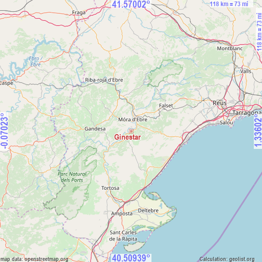
Ginestar GPS coordinates[2]
41° 2' 30.624" North, 0° 37' 58.44" East
| Map corner | latitude | longitude |
|---|---|---|
| Upper-left | 41.57002°, | -0.07023° |
| Center: | 41.04184°, | 0.6329° |
| Lower-right: | 40.50939°, | 1.33602° |
| Map W x H: | 117.9×117.9 km | = 73.3×73.3mi |
| max Lat: | 43.74134° ⇑50.5% North |
| Ginestar: | 41.04184° |
| min Lat: | ⇓49.5% South 27.64134° |
| min Long | Ginestar | max Long |
| -18.00367° | 0.6329° | 4.2899° |
| W 89.5%⇐ | ⇒10.5% E |
Elevation
Elevation of Ginestar is 31 m = 102 ft, and this is 567 m = 1860 ft below average elevation for this country.
| Max E: |
1682 m = 5518 ft | 94% |
| Avg. | 598 m = 1962 ft | |
| Ginestar | 31 m = 102 ft | |
Min E: |
0 m = 0 ft | 6% |
See also: Spain elevation on elevation.city.
Geographical zone
Ginestar is located in North temperate zone (between Tropic of Cancer and the Arctic Circle). Distance of this Northern Tropic circle is 1957.5 km =1216.3 mi to South.| Distance of | km | miles | from Ginestar |
|---|---|---|---|
| North Pole | 5443.6 | 3382.5 | to North |
| Arctic Circle | 2837.7 | 1763.3 | to North |
| Tropic Cancer | 1957.5 | 1216.3 | to South |
| Equator | 4563.4 | 2835.6 | to South |


Nearby cities:
15 places around Ginestar: (largest is in red/bold)
• Ascó
16.7 km =10.4 mi,  340°
340°
• Benifallet
12.2 km =7.6 mi,  232°
232°
• El Perelló
19.8 km =12.3 mi,  160°
160°
• Falset
19.5 km =12.1 mi,  53°
53°
• Gandesa
16.4 km =10.2 mi,  274°
274°
• Garcia
10.3 km =6.4 mi,  8°
8°
• Miravet
3.1 km =1.9 mi,  264°
264°
• Pratdip
20 km =12.4 mi,  86°
86°
• Rasquera
5.2 km =3.2 mi,  212°
212°
• Tivenys
18 km =11.2 mi, 214°
• Tivissa
8.5 km =5.3 mi,  96°
96°
• Vilalba dels Arcs
19.9 km =12.4 mi,  294°
294°
• Vinebre
16.3 km =10.1 mi,  347°
347°
• el Masroig
13.2 km =8.2 mi,  39°
39°
• la Fatarella
18.7 km =11.6 mi,  317°
317°
Sources, notices
• [Note1] Compared only with cities in Spain existing in our database
• [Src1] Map data: © OpenStreetMap contributors (CC-BY-SA)
• [Src2] Other city data from geonames.org with taken over terms of usage.
• [Src3] Geographical zone / Annual Mean Temperature by Robert A. Rohde @ Wikipedia
