Quinto geodata
Quinto (Aragon) is a seat of a third-order administrative division; located in Spain in Europe/Madrid (GMT+2) time zone. With population of 2,020 people, there are 2155 cities with bigger population in this country. Compared to other cities in Spain, 58.7% of cities are located further ↓South; 81.8% of cities are located further ←West and 83.8% of cities have higher elevation than Quinto. Note1


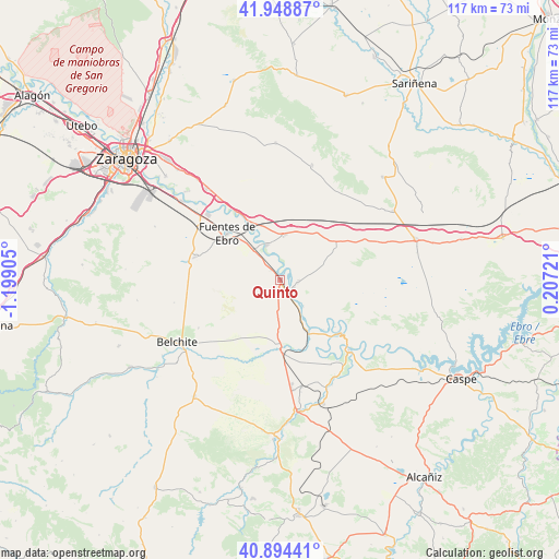
Quinto GPS coordinates[2]
41° 25' 25.608" North, 0° 29' 45.312" West
| Map corner | latitude | longitude |
|---|---|---|
| Upper-left | 41.94887°, | -1.19905° |
| Center: | 41.42378°, | -0.49592° |
| Lower-right: | 40.89441°, | 0.20721° |
| Map W x H: | 117.2×117.2 km | = 72.8×72.8mi |
| max Lat: | 43.74134° ⇑41.3% North |
| Quinto: | 41.42378° |
| min Lat: | ⇓58.7% South 27.64134° |
| min Long | Quinto | max Long |
| -18.00367° | -0.49592° | 4.2899° |
| W 81.8%⇐ | ⇒18.2% E |
Elevation
Elevation of Quinto is 158 m = 518 ft, and this is 440 m = 1444 ft below average elevation for this country.
| Max E: |
1682 m = 5518 ft | 83.8% |
| Avg. | 598 m = 1962 ft | |
| Quinto | 158 m = 518 ft | |
Min E: |
0 m = 0 ft | 16.2% |
See also: Spain elevation on elevation.city.
Geographical zone
Quinto is located in North temperate zone (between Tropic of Cancer and the Arctic Circle). Distance of this Northern Tropic circle is 2000 km =1242.7 mi to South.| Distance of | km | miles | from Quinto |
|---|---|---|---|
| North Pole | 5401.2 | 3356.1 | to North |
| Arctic Circle | 2795.3 | 1736.9 | to North |
| Tropic Cancer | 2000 | 1242.7 | to South |
| Equator | 4605.9 | 2862 | to South |


Nearby cities:
15 places around Quinto: (largest is in red/bold)
• Alborge
15.3 km =9.5 mi,  130°
130°
• Alforque
14 km =8.7 mi,  138°
138°
• Almochuel
16.6 km =10.3 mi,  195°
195°
• Cinco Olivas
14 km =8.7 mi, 131°
• Escatrón
20.6 km =12.8 mi, 135°
• Fuentes de Ebro
15 km =9.3 mi,  311°
311°
• Gelsa
3.4 km =2.1 mi,  122°
122°
• La Puebla de Híjar
22.9 km =14.2 mi,  168°
168°
• La Zaida
12.1 km =7.5 mi,  152°
152°
• Mediana
18.1 km =11.2 mi,  285°
285°
• Nuez de Ebro
23.3 km =14.5 mi,  322°
322°
• Pina de Ebro
7.8 km =4.8 mi,  337°
337°
• Sástago
16.6 km =10.3 mi, 133°
• Velilla de Ebro
7.5 km =4.7 mi, 137°
• Villafranca de Ebro
21.1 km =13.1 mi, 322°
Sources, notices
• [Note1] Compared only with cities in Spain existing in our database
• [Src1] Map data: © OpenStreetMap contributors (CC-BY-SA)
• [Src2] Other city data from geonames.org with taken over terms of usage.
• [Src3] Geographical zone / Annual Mean Temperature by Robert A. Rohde @ Wikipedia
