Pina de Ebro geodata
Pina de Ebro (Aragon) is a populated place; located in Spain in Europe/Madrid (GMT+2) time zone. With population of 2,374 people, there are 1954 cities with bigger population in this country. Compared to other cities in Spain, 60.6% of cities are located further ↓South; 81.3% of cities are located further ←West and 83.7% of cities have higher elevation than Pina de Ebro. Note1


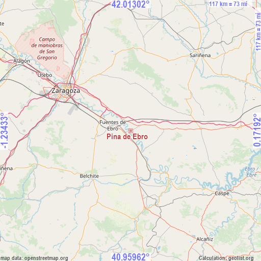
Pina de Ebro GPS coordinates[2]
41° 29' 18.456" North, 0° 31' 52.32" West
| Map corner | latitude | longitude |
|---|---|---|
| Upper-left | 42.01302°, | -1.23433° |
| Center: | 41.48846°, | -0.5312° |
| Lower-right: | 40.95962°, | 0.17192° |
| Map W x H: | 117.1×117.1 km | = 72.8×72.8mi |
| max Lat: | 43.74134° ⇑39.4% North |
| Pina de Ebro: | 41.48846° |
| min Lat: | ⇓60.6% South 27.64134° |
| min Long | Pina de Ebro | max Long |
| -18.00367° | -0.5312° | 4.2899° |
| W 81.3%⇐ | ⇒18.7% E |
Elevation
Elevation of Pina de Ebro is 159 m = 522 ft, and this is 439 m = 1440 ft below average elevation for this country.
| Max E: |
1682 m = 5518 ft | 83.7% |
| Avg. | 598 m = 1962 ft | |
| Pina de Ebro | 159 m = 522 ft | |
Min E: |
0 m = 0 ft | 16.3% |
See also: Spain elevation on elevation.city.
Geographical zone
Pina de Ebro is located in North temperate zone (between Tropic of Cancer and the Arctic Circle). Distance of this Northern Tropic circle is 2007.2 km =1247.2 mi to South.| Distance of | km | miles | from Pina de Ebro |
|---|---|---|---|
| North Pole | 5394 | 3351.7 | to North |
| Arctic Circle | 2788.1 | 1732.4 | to North |
| Tropic Cancer | 2007.2 | 1247.2 | to South |
| Equator | 4613.1 | 2866.4 | to South |


Nearby cities:
15 places around Pina de Ebro: (largest is in red/bold)
• Alborge
22.5 km =14 mi,  139°
139°
• Alfajarín
20 km =12.4 mi,  314°
314°
• Alforque
21.5 km =13.4 mi,  145°
145°
• Cinco Olivas
21.3 km =13.2 mi, 141°
• El Burgo de Ebro
19.8 km =12.3 mi,  297°
297°
• Farlete
21.5 km =13.4 mi,  5°
5°
• Fuentes de Ebro
8.8 km =5.5 mi,  287°
287°
• Gelsa
10.7 km =6.6 mi, 147°
• La Zaida
19.8 km =12.3 mi, 154°
• Mediana
14.7 km =9.1 mi,  260°
260°
• Monegrillo
19.3 km =12 mi,  29°
29°
• Nuez de Ebro
16 km =9.9 mi, 314°
• Quinto
7.8 km =4.8 mi,  157°
157°
• Velilla de Ebro
15 km =9.3 mi, 147°
• Villafranca de Ebro
13.8 km =8.6 mi, 314°
Sources, notices
• [Note1] Compared only with cities in Spain existing in our database
• [Src1] Map data: © OpenStreetMap contributors (CC-BY-SA)
• [Src2] Other city data from geonames.org with taken over terms of usage.
• [Src3] Geographical zone / Annual Mean Temperature by Robert A. Rohde @ Wikipedia
