Alborge geodata
Alborge (Aragon) is a seat of a third-order administrative division; located in Spain in Europe/Madrid (GMT+2) time zone. With population of 128 people, there are 5608 cities with bigger population in this country. Compared to other cities in Spain, 56% of cities are located further ↓South; 83.8% of cities are located further ←West and 84.1% of cities have higher elevation than Alborge. Note1


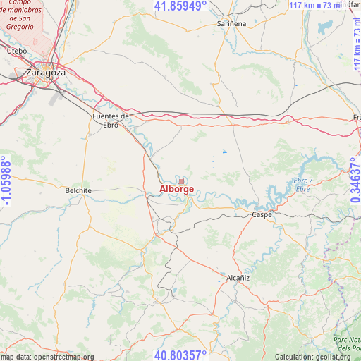
Alborge GPS coordinates[2]
41° 20' 1.212" North, 0° 21' 24.3" West
| Map corner | latitude | longitude |
|---|---|---|
| Upper-left | 41.85949°, | -1.05988° |
| Center: | 41.33367°, | -0.35675° |
| Lower-right: | 40.80357°, | 0.34637° |
| Map W x H: | 117.4×117.4 km | = 72.9×72.9mi |
| max Lat: | 43.74134° ⇑44% North |
| Alborge: | 41.33367° |
| min Lat: | ⇓56% South 27.64134° |
| min Long | Alborge | max Long |
| -18.00367° | -0.35675° | 4.2899° |
| W 83.8%⇐ | ⇒16.2% E |
Elevation
Elevation of Alborge is 154 m = 505 ft, and this is 444 m = 1457 ft below average elevation for this country.
| Max E: |
1682 m = 5518 ft | 84.1% |
| Avg. | 598 m = 1962 ft | |
| Alborge | 154 m = 505 ft | |
Min E: |
0 m = 0 ft | 15.9% |
See also: Spain elevation on elevation.city.
Geographical zone
Alborge is located in North temperate zone (between Tropic of Cancer and the Arctic Circle). Distance of this Northern Tropic circle is 1990 km =1236.5 mi to South.| Distance of | km | miles | from Alborge |
|---|---|---|---|
| North Pole | 5411.2 | 3362.4 | to North |
| Arctic Circle | 2805.3 | 1743.1 | to North |
| Tropic Cancer | 1990 | 1236.5 | to South |
| Equator | 4595.9 | 2855.8 | to South |


Nearby cities:
15 places around Alborge: (largest is in red/bold)
• Alforque
2.4 km =1.5 mi,  258°
258°
• Almochuel
17.3 km =10.7 mi,  249°
249°
• Castelnou
11.7 km =7.3 mi,  183°
183°
• Chiprana
20.7 km =12.9 mi,  112°
112°
• Cinco Olivas
1.4 km =0.9 mi,  298°
298°
• Escatrón
5.5 km =3.4 mi,  149°
149°
• Gelsa
12 km =7.5 mi,  313°
313°
• Híjar
19.4 km =12.1 mi,  203°
203°
• Jatiel
12.8 km =8 mi,  189°
189°
• La Puebla de Híjar
14.3 km =8.9 mi,  209°
209°
• La Zaida
6.1 km =3.8 mi, 263°
• Quinto
15.3 km =9.5 mi, 310°
• Samper de Calanda
16.3 km =10.1 mi, 189°
• Sástago
1.4 km =0.9 mi,  159°
159°
• Velilla de Ebro
7.9 km =4.9 mi, 304°
Sources, notices
• [Note1] Compared only with cities in Spain existing in our database
• [Src1] Map data: © OpenStreetMap contributors (CC-BY-SA)
• [Src2] Other city data from geonames.org with taken over terms of usage.
• [Src3] Geographical zone / Annual Mean Temperature by Robert A. Rohde @ Wikipedia
