Poveda geodata
Poveda (Castille and León) is a seat of a third-order administrative division; located in Spain in Europe/Madrid (GMT+2) time zone. With population of 80 people, there are 6136 cities with bigger population in this country. Compared to other cities in Spain, 60.4% of cities are located further ↑North; 73.5% of cities are located further →East and 96.6% of cities have lower elevation than Poveda. Note1


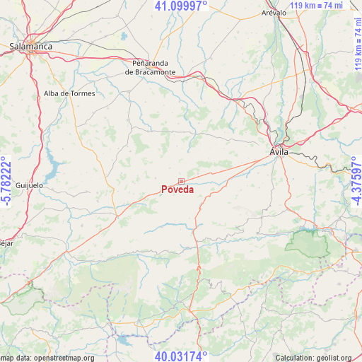
Poveda GPS coordinates[2]
40° 34' 4.764" North, 5° 4' 44.724" West
| Map corner | latitude | longitude |
|---|---|---|
| Upper-left | 41.09997°, | -5.78222° |
| Center: | 40.56799°, | -5.07909° |
| Lower-right: | 40.03174°, | -4.37597° |
| Map W x H: | 118.8×118.8 km | = 73.8×73.8mi |
| max Lat: | 43.74134° ⇑60.4% North |
| Poveda: | 40.56799° |
| min Lat: | ⇓39.6% South 27.64134° |
| min Long | Poveda | max Long |
| -18.00367° | -5.07909° | 4.2899° |
| W 26.5%⇐ | ⇒73.5% E |
Elevation
Elevation of Poveda is 1194 m = 3917 ft, and this is 596 m = 1955 ft above average elevation for this country.
| Max E: |
1682 m = 5518 ft | 3.4% |
| Poveda | 1194 m 3917 ft | |
| Avg. | 598 m = 1962 ft | |
Min E: |
0 m = 0 ft | 96.6% |
See also: Spain elevation on elevation.city.
Geographical zone
Poveda is located in North temperate zone (between Tropic of Cancer and the Arctic Circle). Distance of this Northern Tropic circle is 1904.8 km =1183.6 mi to South.| Distance of | km | miles | from Poveda |
|---|---|---|---|
| North Pole | 5496.3 | 3415.2 | to North |
| Arctic Circle | 2890.4 | 1796 | to North |
| Tropic Cancer | 1904.8 | 1183.6 | to South |
| Equator | 4510.7 | 2802.8 | to South |


Nearby cities:
15 places around Poveda: (largest is in red/bold)
• Amavida
1.3 km =0.8 mi,  61°
61°
• Cepeda la Mora
12.5 km =7.8 mi,  168°
168°
• Garganta del Villar
13.3 km =8.3 mi,  189°
189°
• Hurtumpascual
14.1 km =8.8 mi,  348°
348°
• Manjabálago
10.7 km =6.6 mi,  0°
0°
• Mengamuñoz
10.1 km =6.3 mi,  138°
138°
• Muñana
6 km =3.7 mi,  65°
65°
• Muñotello
4.2 km =2.6 mi,  132°
132°
• Narros del Puerto
7.9 km =4.9 mi,  112°
112°
• Navacepedilla de Corneja
12.7 km =7.9 mi,  224°
224°
• Pradosegar
2.1 km =1.3 mi,  159°
159°
• Vadillo de la Sierra
5.8 km =3.6 mi,  317°
317°
• Valdecasa
11.6 km =7.2 mi,  29°
29°
• Villanueva del Campillo
8.6 km =5.3 mi,  276°
276°
• Villatoro
3.1 km =1.9 mi,  244°
244°
Sources, notices
• [Note1] Compared only with cities in Spain existing in our database
• [Src1] Map data: © OpenStreetMap contributors (CC-BY-SA)
• [Src2] Other city data from geonames.org with taken over terms of usage.
• [Src3] Geographical zone / Annual Mean Temperature by Robert A. Rohde @ Wikipedia
