Manjabálago geodata
Manjabálago (Castille and León) is a seat of a third-order administrative division; located in Spain in Europe/Madrid (GMT+2) time zone. With population of 53 people, there are 6431 cities with bigger population in this country. Compared to other cities in Spain, 58.6% of cities are located further ↑North; 73.5% of cities are located further →East and 98.5% of cities have lower elevation than Manjabálago. Note1
Administrative division(s):
- Level 1: Castille and León
- Level 2: Provincia de Ávila
- Level 3: Manjabálago


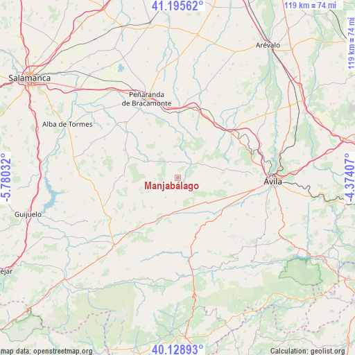
Manjabálago GPS coordinates[2]
40° 39' 51.876" North, 5° 4' 37.884" West
| Map corner | latitude | longitude |
|---|---|---|
| Upper-left | 41.19562°, | -5.78032° |
| Center: | 40.66441°, | -5.07719° |
| Lower-right: | 40.12893°, | -4.37407° |
| Map W x H: | 118.6×118.6 km | = 73.7×73.7mi |
| max Lat: | 43.74134° ⇑58.6% North |
| Manjabálago: | 40.66441° |
| min Lat: | ⇓41.4% South 27.64134° |
| min Long | Manjabálago | max Long |
| -18.00367° | -5.07719° | 4.2899° |
| W 26.5%⇐ | ⇒73.5% E |
Elevation
Elevation of Manjabálago is 1289 m = 4229 ft, and this is 691 m = 2267 ft above average elevation for this country.
| Max E: |
1682 m = 5518 ft | 1.5% |
| Manjabálago | 1289 m 4229 ft | |
| Avg. | 598 m = 1962 ft | |
Min E: |
0 m = 0 ft | 98.5% |
See also: Spain elevation on elevation.city.
Geographical zone
Manjabálago is located in North temperate zone (between Tropic of Cancer and the Arctic Circle). Distance of this Northern Tropic circle is 1915.5 km =1190.2 mi to South.| Distance of | km | miles | from Manjabálago |
|---|---|---|---|
| North Pole | 5485.6 | 3408.6 | to North |
| Arctic Circle | 2879.7 | 1789.4 | to North |
| Tropic Cancer | 1915.5 | 1190.2 | to South |
| Equator | 4521.5 | 2809.5 | to South |


Nearby cities:
15 places around Manjabálago: (largest is in red/bold)
• Amavida
10.1 km =6.3 mi,  174°
174°
• Cabezas del Villar
12.5 km =7.8 mi,  297°
297°
• Chamartín
10.9 km =6.8 mi,  67°
67°
• Cillán
9.4 km =5.8 mi,  59°
59°
• Gallegos de Sobrinos
6.5 km =4 mi,  333°
333°
• Hurtumpascual
4.4 km =2.7 mi,  314°
314°
• Muñana
9.8 km =6.1 mi,  147°
147°
• Muñico
6.3 km =3.9 mi,  41°
41°
• Narrillos del Rebollar
9.4 km =5.8 mi,  89°
89°
• Poveda
10.7 km =6.6 mi,  180°
180°
• Pradosegar
12.7 km =7.9 mi, 177°
• San García de Ingelmos
12.1 km =7.5 mi,  344°
344°
• Vadillo de la Sierra
7.6 km =4.7 mi,  212°
212°
• Valdecasa
5.5 km =3.4 mi,  95°
95°
• Villatoro
12.4 km =7.7 mi,  193°
193°
Sources, notices
• [Note1] Compared only with cities in Spain existing in our database
• [Src1] Map data: © OpenStreetMap contributors (CC-BY-SA)
• [Src2] Other city data from geonames.org with taken over terms of usage.
• [Src3] Geographical zone / Annual Mean Temperature by Robert A. Rohde @ Wikipedia
