Hurtumpascual geodata
Hurtumpascual (Castille and León) is a seat of a third-order administrative division; located in Spain in Europe/Madrid (GMT+2) time zone. With population of 102 people, there are 5908 cities with bigger population in this country. Compared to other cities in Spain, 58.2% of cities are located further ↑North; 73.9% of cities are located further →East and 96.2% of cities have lower elevation than Hurtumpascual. Note1
Administrative division(s):
- Level 1: Castille and León
- Level 2: Provincia de Ávila
- Level 3: Hurtumpascual


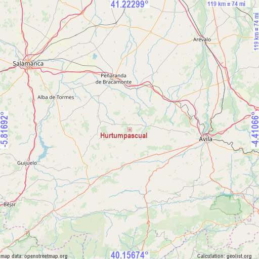
Hurtumpascual GPS coordinates[2]
40° 41' 31.2" North, 5° 6' 49.644" West
| Map corner | latitude | longitude |
|---|---|---|
| Upper-left | 41.22299°, | -5.81692° |
| Center: | 40.692°, | -5.11379° |
| Lower-right: | 40.15674°, | -4.41066° |
| Map W x H: | 118.6×118.6 km | = 73.7×73.7mi |
| max Lat: | 43.74134° ⇑58.2% North |
| Hurtumpascual: | 40.692° |
| min Lat: | ⇓41.8% South 27.64134° |
| min Long | Hurtumpascual | max Long |
| -18.00367° | -5.11379° | 4.2899° |
| W 26.1%⇐ | ⇒73.9% E |
Elevation
Elevation of Hurtumpascual is 1177 m = 3862 ft, and this is 579 m = 1900 ft above average elevation for this country.
| Max E: |
1682 m = 5518 ft | 3.8% |
| Hurtumpascual | 1177 m 3862 ft | |
| Avg. | 598 m = 1962 ft | |
Min E: |
0 m = 0 ft | 96.2% |
See also: Spain elevation on elevation.city.
Geographical zone
Hurtumpascual is located in North temperate zone (between Tropic of Cancer and the Arctic Circle). Distance of this Northern Tropic circle is 1918.6 km =1192.2 mi to South.| Distance of | km | miles | from Hurtumpascual |
|---|---|---|---|
| North Pole | 5482.5 | 3406.7 | to North |
| Arctic Circle | 2876.6 | 1787.4 | to North |
| Tropic Cancer | 1918.6 | 1192.2 | to South |
| Equator | 4524.5 | 2811.4 | to South |


Nearby cities:
15 places around Hurtumpascual: (largest is in red/bold)
• Amavida
13.8 km =8.6 mi,  162°
162°
• Blascomillán
12.4 km =7.7 mi,  10°
10°
• Cabezas del Villar
8.5 km =5.3 mi,  287°
287°
• Chamartín
13.2 km =8.2 mi,  84°
84°
• Cillán
11.3 km =7 mi, 81°
• Gallegos de Sobrinos
2.8 km =1.7 mi,  2°
2°
• Herreros de Suso
13.9 km =8.6 mi,  26°
26°
• Malpartida
12.7 km =7.9 mi,  308°
308°
• Mancera de Arriba
11.4 km =7.1 mi,  345°
345°
• Manjabálago
4.4 km =2.7 mi,  134°
134°
• Muñico
7.5 km =4.7 mi, 77°
• Narrillos del Rebollar
12.8 km =8 mi,  103°
103°
• San García de Ingelmos
8.6 km =5.3 mi,  359°
359°
• Vadillo de la Sierra
9.6 km =6 mi,  185°
185°
• Valdecasa
9.3 km =5.8 mi,  112°
112°
Sources, notices
• [Note1] Compared only with cities in Spain existing in our database
• [Src1] Map data: © OpenStreetMap contributors (CC-BY-SA)
• [Src2] Other city data from geonames.org with taken over terms of usage.
• [Src3] Geographical zone / Annual Mean Temperature by Robert A. Rohde @ Wikipedia
