Plenas geodata
Plenas (Aragon) is a seat of a third-order administrative division; located in Spain in Europe/Madrid (GMT+2) time zone. With population of 127 people, there are 5616 cities with bigger population in this country. Compared to other cities in Spain, 51.2% of cities are located further ↓South; 77.5% of cities are located further ←West and 71.5% of cities have lower elevation than Plenas. Note1


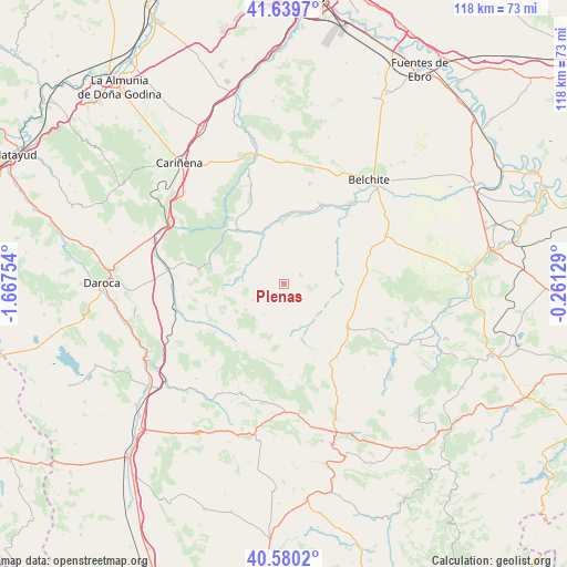
Plenas GPS coordinates[2]
41° 6' 43.524" North, 0° 57' 51.912" West
| Map corner | latitude | longitude |
|---|---|---|
| Upper-left | 41.6397°, | -1.66754° |
| Center: | 41.11209°, | -0.96442° |
| Lower-right: | 40.5802°, | -0.26129° |
| Map W x H: | 117.8×117.8 km | = 73.2×73.2mi |
| max Lat: | 43.74134° ⇑48.8% North |
| Plenas: | 41.11209° |
| min Lat: | ⇓51.2% South 27.64134° |
| min Long | Plenas | max Long |
| -18.00367° | -0.96442° | 4.2899° |
| W 77.5%⇐ | ⇒22.5% E |
Elevation
Elevation of Plenas is 824 m = 2703 ft, and this is 226 m = 741 ft above average elevation for this country.
| Max E: |
1682 m = 5518 ft | 28.5% |
| Plenas | 824 m 2703 ft | |
| Avg. | 598 m = 1962 ft | |
Min E: |
0 m = 0 ft | 71.5% |
See also: Spain elevation on elevation.city.
Geographical zone
Plenas is located in North temperate zone (between Tropic of Cancer and the Arctic Circle). Distance of this Northern Tropic circle is 1965.3 km =1221.2 mi to South.| Distance of | km | miles | from Plenas |
|---|---|---|---|
| North Pole | 5435.8 | 3377.6 | to North |
| Arctic Circle | 2829.9 | 1758.4 | to North |
| Tropic Cancer | 1965.3 | 1221.2 | to South |
| Equator | 4571.2 | 2840.4 | to South |


Nearby cities:
15 places around Plenas: (largest is in red/bold)
• Allueva
15.5 km =9.6 mi,  204°
204°
• Anadón
14.5 km =9 mi,  186°
186°
• Blesa
9.5 km =5.9 mi,  135°
135°
• Bádenas
13.4 km =8.3 mi,  260°
260°
• Herrera de los Navarros
14.7 km =9.1 mi,  317°
317°
• Huesa del Común
11.9 km =7.4 mi,  161°
161°
• Loscos
7.5 km =4.7 mi,  242°
242°
• Moneva
10.9 km =6.8 mi,  80°
80°
• Monforte de Moyuela
7.6 km =4.7 mi,  213°
213°
• Moyuela
3.9 km =2.4 mi,  63°
63°
• Muniesa
15.5 km =9.6 mi,  124°
124°
• Nogueras
9 km =5.6 mi,  286°
286°
• Plou
16.2 km =10.1 mi,  145°
145°
• Santa Cruz de Nogueras
10.5 km =6.5 mi,  271°
271°
• Villar de los Navarros
8.4 km =5.2 mi,  309°
309°
Sources, notices
• [Note1] Compared only with cities in Spain existing in our database
• [Src1] Map data: © OpenStreetMap contributors (CC-BY-SA)
• [Src2] Other city data from geonames.org with taken over terms of usage.
• [Src3] Geographical zone / Annual Mean Temperature by Robert A. Rohde @ Wikipedia
