Pinseque geodata
Pinseque (Aragon) is a seat of a third-order administrative division; located in Spain in Europe/Madrid (GMT+2) time zone. With population of 2,367 people, there are 1958 cities with bigger population in this country. Compared to other cities in Spain, 67% of cities are located further ↓South; 76.3% of cities are located further ←West and 79.4% of cities have higher elevation than Pinseque. Note1


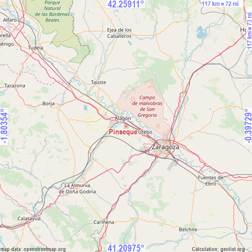
Pinseque GPS coordinates[2]
41° 44' 11.652" North, 1° 6' 1.476" West
| Map corner | latitude | longitude |
|---|---|---|
| Upper-left | 42.25911°, | -1.80354° |
| Center: | 41.73657°, | -1.10041° |
| Lower-right: | 41.20975°, | -0.39729° |
| Map W x H: | 116.7×116.7 km | = 72.5×72.5mi |
| max Lat: | 43.74134° ⇑33% North |
| Pinseque: | 41.73657° |
| min Lat: | ⇓67% South 27.64134° |
| min Long | Pinseque | max Long |
| -18.00367° | -1.10041° | 4.2899° |
| W 76.3%⇐ | ⇒23.7% E |
Elevation
Elevation of Pinseque is 230 m = 755 ft, and this is 368 m = 1207 ft below average elevation for this country.
| Max E: |
1682 m = 5518 ft | 79.4% |
| Avg. | 598 m = 1962 ft | |
| Pinseque | 230 m = 755 ft | |
Min E: |
0 m = 0 ft | 20.6% |
See also: Spain elevation on elevation.city.
Geographical zone
Pinseque is located in North temperate zone (between Tropic of Cancer and the Arctic Circle). Distance of this Northern Tropic circle is 2034.8 km =1264.4 mi to South.| Distance of | km | miles | from Pinseque |
|---|---|---|---|
| North Pole | 5366.4 | 3334.5 | to North |
| Arctic Circle | 2760.5 | 1715.3 | to North |
| Tropic Cancer | 2034.8 | 1264.4 | to South |
| Equator | 4640.7 | 2883.6 | to South |


Nearby cities:
15 places around Pinseque: (largest is in red/bold)
• Alagón
4 km =2.5 mi,  337°
337°
• Alcalá de Ebro
11.7 km =7.3 mi,  318°
318°
• Bardallur
10.9 km =6.8 mi,  237°
237°
• Bárboles
7.7 km =4.8 mi,  246°
246°
• Cabañas de Ebro
10.9 km =6.8 mi,  310°
310°
• Figueruelas
7 km =4.3 mi,  298°
298°
• Grisén
5.2 km =3.2 mi,  280°
280°
• Pedrola
11.2 km =7 mi, 302°
• Plasencia de Jalón
12.4 km =7.7 mi, 240°
• Pleitas
8.9 km =5.5 mi, 251°
• Remolinos
13.1 km =8.1 mi,  330°
330°
• Sobradiel
5.2 km =3.2 mi,  87°
87°
• Torres de Berrellén
3.7 km =2.3 mi,  50°
50°
• Urrea de Jalón
13.5 km =8.4 mi, 235°
• Utebo
9 km =5.6 mi,  110°
110°
Sources, notices
• [Note1] Compared only with cities in Spain existing in our database
• [Src1] Map data: © OpenStreetMap contributors (CC-BY-SA)
• [Src2] Other city data from geonames.org with taken over terms of usage.
• [Src3] Geographical zone / Annual Mean Temperature by Robert A. Rohde @ Wikipedia
